
Make a donation
Kerala topographic map
Click on the map to display elevation.
Make a donation
Kerala
Kerala was alternatively called Malabar in the foreign trade circles. Earlier, the term Malabar had also been used to denote Tulu Nadu and Kanyakumari which lie contiguous to Kerala on the southwestern coast of India, in addition to the modern state of Kerala. The people of Malabar were known as Malabars. Until the arrival of the East India Company, the term Malabar was used as a general name for Kerala, along with the term Kerala. From the time of Cosmas Indicopleustes (6th century CE) itself, the Arab sailors used to call Kerala as Male. The first element of the name, however, is attested already in the Topography written by Cosmas Indicopleustes. This mentions a pepper emporium called Male, which clearly gave its name to Malabar ('the country of Male'). The name Male is thought to come from the Malayalam word Mala ('hill'). Al-Biruni (973–1048 CE) is the first known writer to call this country Malabar. Authors such as Ibn Khordadbeh and Al-Baladhuri mention Malabar ports in their works. The Arab writers had called this place Malibar, Manibar, Mulibar, and Munibar. Malabar is reminiscent of the word Malanad which means the land of hills. According to William Logan, the word Malabar comes from a combination of the Malayalam word Mala (hill) and the Persian/Arabic word Barr (country/continent).
Make a donation
About this map
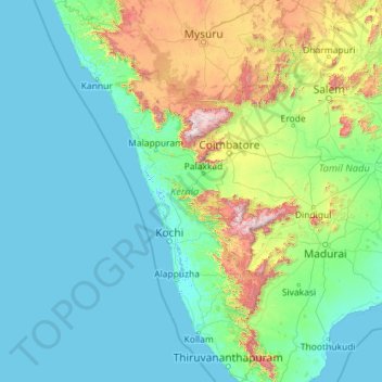
Name: Kerala topographic map, elevation, terrain.
Location: Kerala, India (8.29353 74.86407 12.79606 77.41236)
Average elevation: 251 m
Minimum elevation: -4 m
Maximum elevation: 2,557 m
Make a donation
Other topographic maps
Click on a map to view its topography, its elevation and its terrain.
Make a donation
Maharashtra
Maharashtra is the third largest state by area in India. The Western Ghats better known as Sahyadri, are a hilly range running parallel to the coast, at an average elevation of 1,200 metres (4,000 ft). Kalsubai, a peak in the Sahyadris, near Nashik city is the highest elevated point in Maharashtra. To the west…
Average elevation: 478 m
Make a donation
Dehradun
India > Uttarakhand > Dehradun
The city of Dehradun mainly lies in Doon Valley and is at a varying height from 410 m (1,350 ft) in Clement Town to above 700 m (2,300 ft) at Malsi which is 15 km (9.3 mi) from the city. However, the average elevation is 450 m (1,480 ft) above sea level. Malsi is the starting point of Lesser Himalayan Range…
Average elevation: 904 m
Chengalpattu
India > Tamil Nadu > Chengalpattu
Chengalpattu is located at 12°42′N 79°59′E / 12.7°N 79.98°E / 12.7; 79.98. It has an average elevation of 36 metres (118 ft). Lake Kolavai is the largest located in Chengalpattu.
Average elevation: 48 m
Make a donation
Mussoorie
India > Uttarakhand > Dehradun
Mussoorie is at an average altitude of 2,005 metres (6,578 ft). To the northeast are the Himalayan snow ranges, and to the south, the Doon Valley and Shiwalik ranges. The second highest point is the original Lal Tibba in Landour, with a height of over 2,275 m (7,464 ft). Mussoorie is popularly known as The…
Average elevation: 1,594 m
Make a donation
Bhopal
India > Madhya Pradesh > Huzur Tahsil
Bhopal has an average elevation of 500 metres (1401 ft) and is located in the central part of India, just north of the upper limit of the Vindhya mountain ranges. Located on the Malwa plateau, it is higher than the north Indian plains and the land rises towards the Vindhya Range to the south. The city has…
Average elevation: 498 m
Kalpetta
Kalpetta is a city and town and Wayanad Grade 2 municipality in the Wayanad district of the Indian state of Kerala. Kalpetta is the headquarters of the Wayanad district, as well as the headquarters of Vythiri taluk. It is surrounded by dense coffee and tea plantations and mountains. It lies on the…
Average elevation: 809 m
Gangtok
India > Sikkim > Gangtok subdivision
Gangtok (Nepali: gāntok, pronounced [gantok], Sikkimese: [ɡaŋt̪ʰòk]) is the capital and the most populous city of the Indian state of Sikkim. The seat of eponymous district, Gangtok is in the eastern Himalayan range, at an elevation of 1,650 m (5,410 ft). The city's population of 100,000 consists of the…
Average elevation: 1,911 m
Make a donation
Make a donation
Leh
Leh (/ˈlɛ/) (Ladakhi: གླེ) is the joint capital and largest city of Ladakh, a union territory of India. Leh, located in the Leh district, was also the historical capital of the Kingdom of Ladakh, the seat of which was in the Leh Palace, the former residence of the royal family of Ladakh, built in the…
Average elevation: 4,294 m
Dharamshala
India > Himachal Pradesh > Dharamshala
Dharamshala has an average elevation of 1,457 m (4,780 ft), covering an area of almost 8.51 km2 (3.29 sq mi). Dharamsala is located in the Kangra Valley, in the shadow of the Dhauladhar mountains.
Average elevation: 1,781 m
Make a donation
Mangaluru
India > Karnataka > Mangaluru taluk
Mangalore is also the administrative headquarters of the Dakshina Kannada district; it is a commercial, industrial, educational, healthcare, and startup hub. The city's international airport is the second-largest and second-busiest airport in Karnataka. Mangalore City Corporation is responsible for the civic…
Average elevation: 25 m
Nainital
India > Uttarakhand > Nainital
The city of Nainital covers a total area of 11.73 km2 (4.53 sq mi), and is located at 29°23′N 79°27′E / 29.38°N 79.45°E / 29.38; 79.45, at an average elevation of 2,084 metres (6,837 ft) above sea level. The slopes of the nearby mountains are most populated, with an elevation ranging from…
Average elevation: 1,813 m
Sagar
India > Madhya Pradesh > Sagar Nagar Tahsil
Sagar has an average elevation of 427 metres (1401 ft) and is located in the central part of India, just north of the upper limit of the Vindhya mountain ranges.here is a lake in middle of the city.
Average elevation: 515 m
Make a donation
Guwahati
Professor Abani Kumar Bhagawati of Gauhati University stated that since before there were sufficient wetlands to absorb rainwater and channels to carry excess water to the Brahmaputra, the city did not experience floods. However, human interference has disrupted the natural topography, leading to the current…
Average elevation: 113 m
Mumbai
Mumbai lies at the mouth of the Ulhas River on the western coast of India, in the coastal region known as the Konkan. It sits on Salsette Island (Sashti Island), which it partially shares with the Thane district. Mumbai is bounded by the Arabian Sea to the west. Many parts of the city lie just above sea level,…
Average elevation: 13 m
Make a donation
Daulat Beg Oldi
Daulat Beg Oldi (DBO) lies at the northeastern corner of the Karakoram Range, at the northern edge of Depsang Plains at an elevation of 5,100 metres (16,700 ft). The international border with China is 8 km to the north and the Line of Actual Control with Chinese-controlled Aksai Chin is 9 km to the east. Other…
Average elevation: 5,085 m
Prayagraj
India > Uttar Pradesh > Prayagraj
Prayagraj's elevation is over 90 m (295 ft) above sea level. The old part of the city, at the south of Prayagraj Junction railway station, consists of neighbourhoods like Chowk, Johnstongunj, Dariyabad, Khuldabad and many more. In the north of the Railway Station, the new city consists of neighbourhoods like…
Average elevation: 91 m
Make a donation
Make a donation
Make a donation
Make a donation
Make a donation
Make a donation
Secunderabad
Situated in the North of Hyderabad at 17°27′N 78°30′E / 17.45°N 78.5°E / 17.45; 78.5., Secunderabad lies on the northern part of the Deccan Plateau. Secunderabad has an average elevation of 543 metres (1781 ft). Most of the area has a rocky terrain and some areas are hilly.
Average elevation: 544 m
Mahad
India > Maharashtra > Mahad Taluka
Several disasters like floods and landslides have continuously devastated markets and old houses, specifically classic Konkani-styled architecture, causing great loss of life. This is primarily due to lower elevation of the city compared to surrounding areas and being surrounded by rivers on all sides, making…
Average elevation: 75 m
Kannur
India > Kerala > Kannur > Kannur
Kannur has an elevation of 1.02 metres or 3.3 feet along the coast of the Laccadive Sea, with a sandy coastal area. The city has an 8 kilometres (5.0 mi)-long seashore and a 3 kilometres (1.9 mi)-long beach at Payyambalam. Kannur is located north of Kozhikode, south of Kasargod and Mangalore, west of the…
Average elevation: 13 m
Make a donation
Vadodara
India > Gujarat > Vadodara Rural Taluka
Vadodara is located at 22°18′N 73°11′E / 22.30°N 73.19°E / 22.30; 73.19 in western India at an elevation of 39 metres (128 ft). It is the tenth-largest city in India with an area of 400 square kilometres (150 sq mi) and a population of 3.5 million, according to the 2010–11 census. The city…
Average elevation: 36 m
Salem
Salem is located at 11°40′N 78°08′E / 11.67°N 78.14°E / 11.67; 78.14, at an average elevation of 278 m (912 ft). The city is surrounded by hills: Nagaramalai on the north, Jarugumalai on the south, Kanjamalai on the west, Godumalai on the east and the Shevaroy Hills on the northeast.…
Average elevation: 418 m
Make a donation
Indrasan
India > Himachal Pradesh > Lahul
Mount Indrasan is located at an altitude of 6221 metres above sea level in Kullu district, Himachal Pradesh. Mt. Indrasan is considered as the most difficult mountain to climb in the Pir Panjal range of the Himalayas because of the challenges involved in scaling it. It was first climbed on October 13, 1962, by…
Average elevation: 5,374 m
Losal
India > Rajasthan > Danta Ramgarh Tehsil
Losal is located at 27°24′N 74°55′E / 27.4°N 74.92°E / 27.4; 74.92. It has an average elevation of 410 meters (1345 feet). Losal lays 100 km northeast of Jaipur.
Average elevation: 416 m
Make a donation
Make a donation
Make a donation
Make a donation
Western Ghats
The range starts near south of the Tapti river and runs approximately 1,600 km (990 mi) through the states of Gujarat, Maharashtra, Karnataka, Goa, Kerala and Tamil Nadu ending at Marunthuvazh Malai near the southern tip of India. These hills cover 160,000 km2 (62,000 sq mi) and form the catchment area for…
Average elevation: 2,225 m
Make a donation
Almora
India > Uttarakhand > Almora
Almora is located at 29°35′50″N 79°39′33″E / 29.5971°N 79.6591°E / 29.5971; 79.6591 in Almora district in Uttarakhand. Almora is situated 365 km north-east the national capital New Delhi and 415 km south-east the state capital Dehradun. It lies in the revenue Division Kumaon and is located…
Average elevation: 1,557 m
Surat
India > Gujarat > Katargam Taluka > Surat
Surat is a port city situated on the banks of the Tapi river. Damming of the Tapi caused the original port facilities to close; the nearest port is now in the Magadalla and Hazira area of Surat Metropolitan Region.It has famous beach called 'Dumas Beach' located in Hazira. The city is located at 21°10′N…
Average elevation: 11 m
Make a donation
Ujjain
India > Madhya Pradesh > Ujjain NagarTahsil
Ujjain is located in the west-central part of India, and is north of the upper limit of the Vindhya mountain ranges. Located on the Malwa plateau, it is higher than the north Indian plains and the land rises towards the Vindhya Range to the south. Ujjain's co-ordinates are 23°10′N 75°46′E /…
Average elevation: 501 m
Madurai
India > Tamil Nadu > Madurai
Madurai is located at 9°56′N 78°07′E / 9.93°N 78.12°E / 9.93; 78.12. It has an average elevation of 101 metres. The city of Madurai lies on the flat and fertile plain of the river Vaigai, which runs in the northwest-southeast direction through the city, dividing it into two almost equal…
Average elevation: 138 m
Kolkata
Spread roughly north–south along the east bank of the Hooghly River, Kolkata sits within the lower Ganges Delta of eastern India approximately 75 km (47 mi) west of the international border with Bangladesh; the city's elevation is 1.5–9 m (5–30 ft). Much of the city was originally a wetland that was…
Average elevation: 5 m
Make a donation
Make a donation