
Colombia topographic map
Interactive map
Click on the map to display elevation.
About this map
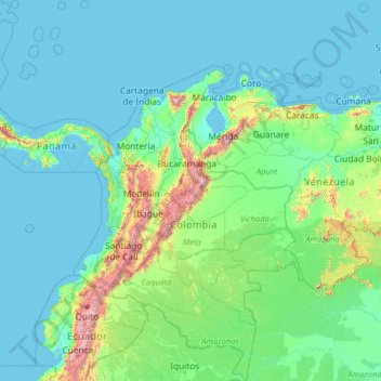
Name: Colombia topographic map, elevation, terrain.
Location: Colombia (-4.22940 -82.12436 16.04955 -66.84904)
Average elevation: 248 m
Minimum elevation: -2 m
Maximum elevation: 5,809 m
The climate of Colombia is characterized for being tropical presenting variations within six natural regions and depending on the altitude, temperature, humidity, winds and rainfall. Colombia has a diverse range of climate zones, including tropical rainforests, savannas, steppes, deserts and mountain climates.
Other topographic maps
Click on a map to view its topography, its elevation and its terrain.
India
India
Average elevation: 1,017 m
Montreal
Canada > Quebec > Urban agglomeration of Montreal > Montreal
Montreal, Urban agglomeration of Montreal, Montreal (06), Quebec, H3B 1M7, Canada
Average elevation: 30 m
Sri Lanka
Sri Lanka
Average elevation: 50 m
Hyderabad
India > Telangana > Bahadurpura mandal
Hyderabad, Bahadurpura mandal, Hyderabad District, Telangana, India
Average elevation: 549 m
Bengaluru
India > Karnataka > Bangalore North
Bengaluru, Bangalore North, Bengaluru Urban District, Karnataka, India
Average elevation: 881 m
Dehradun
India > Uttarakhand > Dehradun
Dehradun, Dehradun District, Uttarakhand, 248001, India
Average elevation: 904 m
Hays County
United States of America > Texas
Hays County, Texas, United States of America
Average elevation: 285 m
Kandy
Kandy, Kandy District, Central Province, 20000, Sri Lanka
Average elevation: 621 m
Madurai
India > Tamil Nadu > Madurai
Madurai, Madurai South, Madurai district, Tamil Nadu, India
Average elevation: 138 m
Panvel
India > Maharashtra > Panvel > Panvel
Panvel, Raigad, Maharashtra, 410206, India
Average elevation: 75 m
Petrópolis
Brazil > Rio de Janeiro > Região Metropolitana do Rio de Janeiro
Petrópolis, Região Geográfica Imediata de Petrópolis, Região Metropolitana do Rio de Janeiro, Região Geográfica Intermediária de Petrópolis, Rio de Janeiro, Southeast Region, Brazil
Average elevation: 832 m
Bondapalli
India > Andhra Pradesh > Bondapalle
Bondapalli, Bondapalle, Vizianagaram, Andhra Pradesh, 531260, India
Average elevation: 72 m
Bodhupatti
India > Tamil Nadu > Namakkal
Bodhupatti, Namakkal, Namakkal District, Tamil Nadu, 637002, India
Average elevation: 193 m
Clappana
India > Kerala > Karunagappally
Clappana, Karunagappally, Kollam District, Kerala, 690525, India
Average elevation: 5 m
Tacoma
United States > Washington > Pierce County
Tacoma, Pierce County, Washington, United States
Average elevation: 67 m
Snohomish County
Snohomish County, Washington, United States
Average elevation: 649 m
Chennai
India > Tamil Nadu > Chennai
Chennai, Chennai District, Tamil Nadu, India
Average elevation: 8 m
Mangaluru
India > Karnataka > Mangaluru taluk
Mangaluru, Mangaluru taluk, Dakshina Kannada District, Karnataka, 575001, India
Average elevation: 25 m
Delhi
India > Delhi > Kotwali Tehsil
Delhi, Kotwali Tehsil, Central Delhi, Delhi, 110006, India
Average elevation: 216 m
Pune
India > Maharashtra > Pune City > Pune
Pune, Pune City, Pune District, Maharashtra, 411001, India
Average elevation: 641 m
Kapugollewa
Sri Lanka > North Central Province
Kapugollewa, Anuradhapura District, North Central Province, Sri Lanka
Average elevation: 65 m
Kebitigollewa
Sri Lanka > North Central Province
Kebitigollewa, Anuradhapura District, North Central Province, Sri Lanka
Average elevation: 108 m
Uhana
Uhana, Ampara District, Eastern Province, Sri Lanka
Average elevation: 42 m
Central Camp
United States > California > Madera County
Central Camp, Madera County, California, United States
Average elevation: 1,745 m
Namaloya
Namaloya, Ampara District, Eastern Province, Sri Lanka
Average elevation: 91 m
Kalmunai
Kalmunai, Ampara District, Eastern Province, 31300, Sri Lanka
Average elevation: 2 m
Akkaraipattu
Akkaraipattu, Ampara District, Eastern Province, 32400, Sri Lanka
Average elevation: 3 m
Malwaththai
Malwaththai, Ampara District, Eastern Province, Sri Lanka
Average elevation: 16 m
Sadaramangala
India > Karnataka > Bangalore East
Sadaramangala, K Dommasandra, Bangalore East, Bengaluru Urban, Karnataka, 560067, India
Average elevation: 880 m
Oddapalem
India > Andhra Pradesh > Muthukur > Oddapalem
Oddapalem, Muthukur, Sri Potti Sriramulu Nellore, Andhra Pradesh, 524346, India
Average elevation: 8 m
Saadiyat Island
United Arab Emirates > Abu Dhabi Emirate > Abu Dhabi > Abu Dhabi
Saadiyat Island, Abu Dhabi, Abu Dhabi Emirate, United Arab Emirates
Average elevation: 1 m
gehunlad
India > Uttarakhand > Chaubatta Khal
gehunlad, Chaubatta Khal, Pauri Garhwal District, Uttarakhand, India
Average elevation: 1,625 m
Naula
India > Uttarakhand > Bhanoli
Naula, Bhanoli, Almora District, Uttarakhand, India
Average elevation: 1,562 m
Asundi
India > Karnataka > Bellary taluk
Asundi, Bellary taluk, Ballari District, Karnataka, India
Average elevation: 419 m
Ocheretyne
Ocheretyne, Ocheretyne settlement hromada, Pokrovskii Raion, Donetsk Oblast, 86020, Ukraine
Average elevation: 227 m