
Badulla District topographic map
Interactive map
Click on the map to display elevation.
About this map
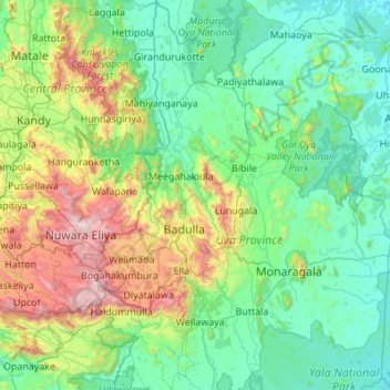
Name: Badulla District topographic map, elevation, terrain.
Location: Badulla District, Uva Province, Sri Lanka (6.54217 80.77594 7.62496 81.27160)
Average elevation: 475 m
Minimum elevation: 16 m
Maximum elevation: 2,486 m
Other topographic maps
Click on a map to view its topography, its elevation and its terrain.
Kebillawela North
Sri Lanka > Uva Province > Bandarawela > Kebillawela North
Average elevation: 1,213 m
Bandarawela
Bandarawela (Sinhala: බණ්ඩාරවෙල, pronounced [banˈda:rawela]; Tamil: பண்டாரவளை) is the second largest town in the Badulla District which is 28 km (17 mi) away from Badulla. Bandarawela is 200 km (120 mi) away from Colombo and about 125 km (78 mi) away from Kandy, the two…
Average elevation: 1,293 m