
Thank you for supporting this site ❤️
Make a donation
Make a donation
Koslanda topographic map
Click on the map to display elevation.
Thank you for supporting this site ❤️
Make a donation
Make a donation
About this map
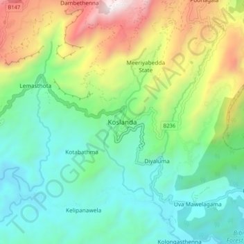
Name: Koslanda topographic map, elevation, terrain.
Location: Koslanda, Badulla District, Uva Province, Sri Lanka (6.70357 80.97825 6.78357 81.05825)
Average elevation: 837 m
Minimum elevation: 358 m
Maximum elevation: 1,907 m
Thank you for supporting this site ❤️
Make a donation
Make a donation
Other topographic maps
Click on a map to view its topography, its elevation and its terrain.