
Galle District topographic map
Interactive map
Click on the map to display elevation.
About this map
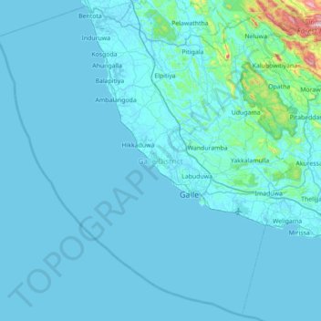
Name: Galle District topographic map, elevation, terrain.
Location: Galle District, Southern Province, Sri Lanka (5.76900 79.79310 6.44227 80.49576)
Average elevation: 38 m
Minimum elevation: -1 m
Maximum elevation: 913 m
Other topographic maps
Click on a map to view its topography, its elevation and its terrain.
Thawalama Junction
Sri Lanka > Southern Province > Thawalama > Thawalama Junction
Average elevation: 71 m