
Thank you for supporting this site ❤️
Make a donation
Make a donation
Getamanna topographic map
Click on the map to display elevation.
Thank you for supporting this site ❤️
Make a donation
Make a donation
About this map
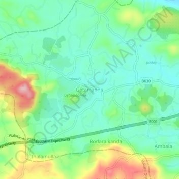
Name: Getamanna topographic map, elevation, terrain.
Location: Getamanna, Hambantota District, Southern Province, Sri Lanka (6.02074 80.66089 6.06074 80.70089)
Average elevation: 89 m
Minimum elevation: 32 m
Maximum elevation: 213 m
Thank you for supporting this site ❤️
Make a donation
Make a donation