
Thank you for supporting this site ❤️
Make a donation
Make a donation
Poddana topographic map
Click on the map to display elevation.
Thank you for supporting this site ❤️
Make a donation
Make a donation
About this map
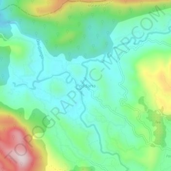
Name: Poddana topographic map, elevation, terrain.
Location: Poddana, Matara District, Southern Province, 81500, Sri Lanka (6.32774 80.47950 6.36774 80.51950)
Average elevation: 382 m
Minimum elevation: 245 m
Maximum elevation: 717 m
Thank you for supporting this site ❤️
Make a donation
Make a donation