
長野市 topographic map
Interactive map
Click on the map to display elevation.
About this map
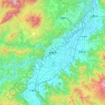
Name: 長野市 topographic map, elevation, terrain.
Location: 長野市, 長野県, 380-8512, 日本 (36.48859 138.03477 36.80859 138.35477)
Average elevation: 761 m
Minimum elevation: 312 m
Maximum elevation: 2,321 m
長野市は長野県北部の中心都市であり、長野県庁の本庁舎も立地している。この長野県庁の本庁舎は、標高371.3メートルの地点に建っており、日本の47都道府県の中で最も高いことで知られている。
Other topographic maps
Click on a map to view its topography, its elevation and its terrain.