
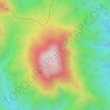
大東岳 topographic map
Interactive map
Click on the map to display elevation.
About this map
Name: 大東岳 topographic map, elevation, terrain.
Location: 大東岳, 仙台市, 宮城県, 日本 (38.30211 140.52350 38.30221 140.52360)
Average elevation: 926 m
Minimum elevation: 622 m
Maximum elevation: 1,352 m
Other topographic maps
Click on a map to view its topography, its elevation and its terrain.