
Switzerland topographic map
Interactive map
Click on the map to display elevation.
About this map
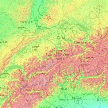
Name: Switzerland topographic map, elevation, terrain.
Location: Switzerland (45.81797 5.95591 47.80846 10.49229)
Average elevation: 1,016 m
Minimum elevation: 41 m
Maximum elevation: 4,564 m
Switzerland lies between latitudes 45° and 48° N, and longitudes 5° and 11° E. It contains three basic topographical areas: the Swiss Alps to the south, the Swiss Plateau or Central Plateau, and the Jura mountains on the west. The Alps are a mountain range running across the central and south of the country, constituting about 60% of the country's area. The majority of the population live on the Swiss Plateau. The Swiss Alps host many glaciers, covering 1,063 square kilometres (410 sq mi). From these originate the headwaters of several major rivers, such as the Rhine, Inn, Ticino and Rhône, which flow in the four cardinal directions, spreading across Europe. The hydrographic network includes several of the largest bodies of fresh water in Central and Western Europe, among which are Lake Geneva (Lac Léman in French), Lake Constance (Bodensee in German) and Lake Maggiore. Switzerland has more than 1500 lakes and contains 6% of Europe's freshwater stock. Lakes and glaciers cover about 6% of the national territory. Lake Geneva is the largest lake and is shared with France. The Rhône is both the main source and outflow of Lake Geneva. Lake Constance is the second-largest and, like Lake Geneva, an intermediate step by the Rhine at the border with Austria and Germany. While the Rhône flows into the Mediterranean Sea at the French Camargue region and the Rhine flows into the North Sea at Rotterdam, about 1,000 kilometres (620 miles) apart, both springs are only about 22 kilometres (14 miles) apart in the Swiss Alps.
Other topographic maps
Click on a map to view its topography, its elevation and its terrain.
Madurai
India > Tamil Nadu > Madurai
Madurai, Madurai South, Madurai district, Tamil Nadu, India
Average elevation: 138 m
Montreal
Canada > Quebec > Urban agglomeration of Montreal > Montreal
Montreal, Urban agglomeration of Montreal, Montreal (06), Quebec, H3B 1M7, Canada
Average elevation: 30 m
India
India
Average elevation: 1,017 m
Sri Lanka
Sri Lanka
Average elevation: 50 m
Ocheretyne
Ocheretyne, Ocheretyne settlement hromada, Pokrovskii Raion, Donetsk Oblast, 86020, Ukraine
Average elevation: 227 m
Bengaluru
India > Karnataka > Bangalore North
Bengaluru, Bangalore North, Bengaluru Urban District, Karnataka, India
Average elevation: 881 m
Snohomish County
Snohomish County, Washington, United States
Average elevation: 649 m
Pune
India > Maharashtra > Pune City > Pune
Pune, Pune City, Pune District, Maharashtra, 411001, India
Average elevation: 641 m
Hyderabad
India > Telangana > Bahadurpura mandal
Hyderabad, Bahadurpura mandal, Hyderabad District, Telangana, India
Average elevation: 549 m
Kandy
Kandy, Kandy District, Central Province, 20000, Sri Lanka
Average elevation: 621 m
Ooty Lake
India > Tamil Nadu > Udhagamandalam > Udhagamandalam
Ooty Lake, Udhagamandalam, The Nilgiris District, Tamil Nadu, 643001, India
Average elevation: 2,235 m
Navi Mumbai
India > Maharashtra > Thane > Navi Mumbai
Navi Mumbai, Mumbai Metropolitan Region, Thane, Maharashtra, 400706, India
Average elevation: 30 m
Dehradun
India > Uttarakhand > Dehradun
Dehradun, Dehradun District, Uttarakhand, 248001, India
Average elevation: 904 m
Show Low
United States > Arizona > Navajo County
Show Low, Navajo County, Arizona, 85901, United States
Average elevation: 1,957 m
Juno
South Africa > Limpopo > Capricorn District Municipality > Aganang Local Municipality
Juno, Aganang Local Municipality, Capricorn District Municipality, Limpopo, South Africa
Average elevation: 1,104 m
Musi River
Musi River, Hyderabad, Uppal mandal, Medchal–Malkajgiri, Telangana, 5000036, India
Average elevation: 490 m
Devanahalli
India > Karnataka > Devanahalli taluk
Devanahalli, Devanahalli taluk, Bengaluru Rural District, Karnataka, 562110, India
Average elevation: 900 m
Tacoma
United States > Washington > Pierce County
Tacoma, Pierce County, Washington, United States
Average elevation: 67 m
Tibane
Algeria > Bejaia > Chemini District
Tibane, Chemini District, Bejaia, 06730, Algeria
Average elevation: 626 m
Chasiv Yar
Chasiv Yar, Chasiv Yar urban hromada, Bakhmut Raion, Donetsk Oblast, 84551-84556, Ukraine
Average elevation: 213 m
West Hollywood
West Hollywood, California, United States
Average elevation: 122 m
Hays County
United States of America > Texas
Hays County, Texas, United States of America
Average elevation: 285 m
Panvel
India > Maharashtra > Panvel > Panvel
Panvel, Raigad, Maharashtra, 410206, India
Average elevation: 75 m
Lake Kerere
Uganda > Kabarole > Nyabweya A
Lake Kerere, Nyabweya A, Kabarole, Western Region, Uganda
Average elevation: 1,212 m
Casas de Mindaño
Spain > Extremadura > Tornavacas
Casas de Mindaño, Tornavacas, Cáceres, Extremadura, Spain
Average elevation: 1,310 m
Mindoro
Philippines > Occidental Mindoro
Mindoro, Occidental Mindoro, Mimaropa, Philippines
Average elevation: 173 m
Poblacion 4
Philippines > Palawan > Coron
Poblacion 4, Coron, Palawan, Mimaropa, 5316, Philippines
Average elevation: 31 m
Haywood County
United States > North Carolina
Haywood County, North Carolina, United States
Average elevation: 1,044 m
Nepal
Nepal
Average elevation: 2,604 m
Dasada
India > Gujarat > Dasada Taluka
Dasada, Dasada Taluka, Surendranagar District, Gujarat, 382750, India
Average elevation: 28 m
Rampura
India > Madhya Pradesh > Gyaraspur Tahsil
Rampura, Gyaraspur Tahsil, Vidisha District, Madhya Pradesh, India
Average elevation: 460 m
Kabul
Afghanistan > Kabul Province > Kabul District
Kabul, Kabul District, Kabul Province, 1001, Afghanistan
Average elevation: 1,945 m
Bodhupatti
India > Tamil Nadu > Namakkal
Bodhupatti, Namakkal, Namakkal District, Tamil Nadu, 637002, India
Average elevation: 193 m
Yacharam
India > Telangana > Bantwaram mandal
Yacharam, Bantwaram mandal, Vikarabad District, Telangana, India
Average elevation: 574 m
Central Camp
United States > California > Madera County
Central Camp, Madera County, California, United States
Average elevation: 1,745 m