
Thank you for supporting this site ❤️
Make a donation
Make a donation
Hokuto topographic map
Click on the map to display elevation.
Thank you for supporting this site ❤️
Make a donation
Make a donation
About this map
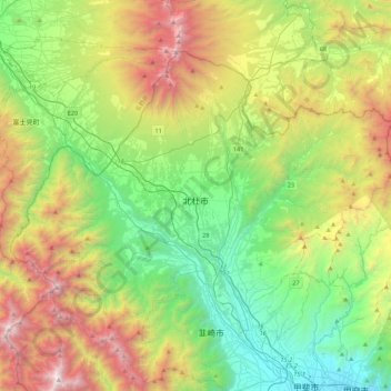
Name: Hokuto topographic map, elevation, terrain.
Location: Hokuto, Yamanashi Prefecture, Chubu Region, Japan (35.70973 138.18517 35.97171 138.62159)
Average elevation: 1,256 m
Minimum elevation: 261 m
Maximum elevation: 3,151 m
Thank you for supporting this site ❤️
Make a donation
Make a donation
Other topographic maps
Click on a map to view its topography, its elevation and its terrain.
Thank you for supporting this site ❤️
Make a donation
Make a donation
Mt. Kumotori
Mount Kumotori (雲取山, Kumotori-san) stands at the boundary of Tokyo, Saitama, and Yamanashi Prefectures on the island of Honshū, Japan. With an elevation of 2,017 metres (6,617 ft), its summit is the highest point in Tokyo. It separates the Okutama Mountains and the Okuchichibu Mountains. While it marks…
Average elevation: 1,625 m
Thank you for supporting this site ❤️
Make a donation
Make a donation