
Make a donation
Koto topographic map
Click on the map to display elevation.
Make a donation
Koto
Kōtō occupies a position on the waterfront of Tokyo Bay sandwiched between the wards of Chūō and Edogawa. To the North, its inland boundary is with the Sumida special ward. Much of the land is reclaimed, The northern part is old reclaimed land, and the elevation is very low (below sea level). The southern part is relatively new, but there are few old temples or shrines.
Make a donation
About this map
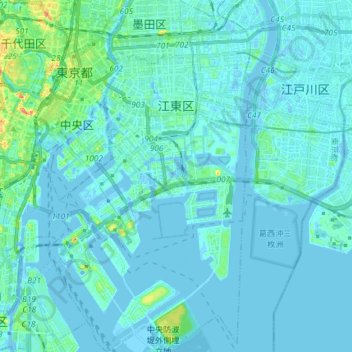
Name: Koto topographic map, elevation, terrain.
Location: Koto, Tokyo, Japan (35.58865 139.76672 35.70809 139.84855)
Average elevation: 5 m
Minimum elevation: -10 m
Maximum elevation: 52 m
Make a donation
Other topographic maps
Click on a map to view its topography, its elevation and its terrain.
Make a donation
Mt. Kumotori
Mount Kumotori (雲取山, Kumotori-san) stands at the boundary of Tokyo, Saitama, and Yamanashi Prefectures on the island of Honshū, Japan. With an elevation of 2,017 metres (6,617 ft), its summit is the highest point in Tokyo. It separates the Okutama Mountains and the Okuchichibu Mountains. While it marks…
Average elevation: 1,625 m
Make a donation