
Make a donation
Utsunomiya topographic map
Click on the map to display elevation.
Make a donation
Utsunomiya
Utsunomiya is located in south-central Tochigi Prefecture in the northern Kantō plains. It is approximately 100 km (60 mi) north of Tokyo. The historic town of Nikkō is approximately 25 km (15 mi) northwest of Utsunomiya. The average elevation of the city is 100 metres (330 ft).
Make a donation
About this map
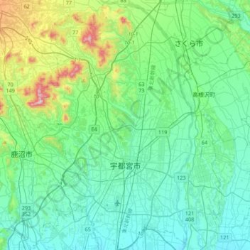
Name: Utsunomiya topographic map, elevation, terrain.
Location: Utsunomiya, Tochigi Prefecture, Japan (36.46397 139.74287 36.73008 140.01076)
Average elevation: 161 m
Minimum elevation: 69 m
Maximum elevation: 549 m
Make a donation
Other topographic maps
Click on a map to view its topography, its elevation and its terrain.
Make a donation
Mt. Kumotori
Mount Kumotori (雲取山, Kumotori-san) stands at the boundary of Tokyo, Saitama, and Yamanashi Prefectures on the island of Honshū, Japan. With an elevation of 2,017 metres (6,617 ft), its summit is the highest point in Tokyo. It separates the Okutama Mountains and the Okuchichibu Mountains. While it marks…
Average elevation: 1,625 m
Make a donation