
Make a donation
Yabu topographic map
Click on the map to display elevation.
Make a donation
Yabu
Yabu is located in the northern part of Hyōgo Prefecture and the Kinki region.The Maruyama River flows from the southeast to the northeast in the eastern part of the city, and the Yoka and Sekinomiya neighborhoods are located along the Yagi River, which is a tributary of the Maruyama River, and the Yabu and Oya areas are located along the Oya River. Part of the city is within the borders of the Hyōnosen-Ushiroyama-Nagisan Quasi-National Park, including Mount Myōken (1139 meters), and Mount Hyōno the city's highest elevation at 1510 meters.
Make a donation
About this map
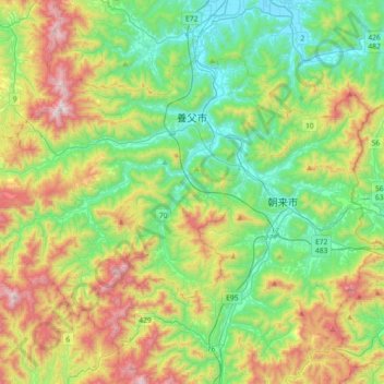
Name: Yabu topographic map, elevation, terrain.
Location: Yabu, Hyogo Prefecture, Japan (35.24165 134.50287 35.45185 134.86293)
Average elevation: 371 m
Minimum elevation: 1 m
Maximum elevation: 1,115 m
Make a donation
Other topographic maps
Click on a map to view its topography, its elevation and its terrain.
Make a donation
Mt. Kumotori
Mount Kumotori (雲取山, Kumotori-san) stands at the boundary of Tokyo, Saitama, and Yamanashi Prefectures on the island of Honshū, Japan. With an elevation of 2,017 metres (6,617 ft), its summit is the highest point in Tokyo. It separates the Okutama Mountains and the Okuchichibu Mountains. While it marks…
Average elevation: 1,625 m
Make a donation