
Shimane Prefecture topographic map
Click on the map to display elevation.
About this map
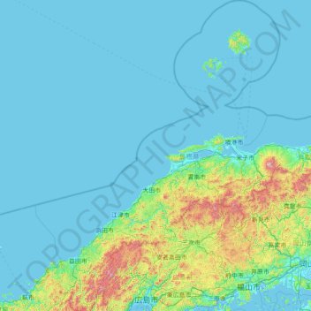
Name: Shimane Prefecture topographic map, elevation, terrain.
Location: Shimane Prefecture, Japan (34.30244 131.46194 36.55577 133.63844)
Average elevation: 123 m
Minimum elevation: -5 m
Maximum elevation: 1,573 m
Other topographic maps
Click on a map to view its topography, its elevation and its terrain.
Mt. Kumotori
Mount Kumotori (雲取山, Kumotori-san) stands at the boundary of Tokyo, Saitama, and Yamanashi Prefectures on the island of Honshū, Japan. With an elevation of 2,017 metres (6,617 ft), its summit is the highest point in Tokyo. It separates the Okutama Mountains and the Okuchichibu Mountains. While it marks…
Average elevation: 1,625 m