
Mahulapada topographic map
Click on the map to display elevation.
About this map
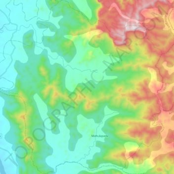
Name: Mahulapada topographic map, elevation, terrain.
Location: Mahulapada, Sundargarh, Odisha, India (21.58987 84.99084 21.78210 85.19425)
Average elevation: 400 m
Minimum elevation: 120 m
Maximum elevation: 1,054 m
Other topographic maps
Click on a map to view its topography, its elevation and its terrain.
Bhubaneshwar
India > Odisha > Bhubaneswar (M.Corp.)
Bhubaneswar is in Khordha district of Odisha. It is in the eastern coastal plains, along the axis of the Eastern Ghats mountains. The city has an average altitude of 45 m (148 ft) above sea level. It lies southwest of the Mahanadi River that forms the northern boundary of Bhubaneswar metropolitan area, within…
Average elevation: 30 m
Cuttack
India > Odisha > Cuttack (M.Corp.) P.S
Cuttack is located at 20°31′23″N 085°47′17″E / 20.52306°N 85.78806°E / 20.52306; 85.78806 and has an average elevation of 36 metres (118 ft). The city is spread across an area of 192.5 km2 (74 sq mi). The city, being a Cuttack Municipal Corporation which consists of 59 wards. The city…
Average elevation: 34 m
Baripada
India > Odisha > Baripada (M)
Baripada is at 21°56′N 86°43′E / 21.94°N 86.72°E / 21.94; 86.72. It has an average elevation of 36 metres (118 feet). The city lies along the Budhabalanga River.
Average elevation: 42 m
Rourkela
India > Odisha > Raurkela (M)
Rourkela is located at 84.54E longitude and 22.12N latitude in Sundergarh district of Odisha at an elevation of about 219 m (719 ft) above mean sea level. The area of Rourkela is 200 square kilometers approximately. Being situated on the Howrah-Mumbai rail track, Rourkela had an added advantage of the steel…
Average elevation: 237 m
Angul
Angul (also known as Anugul) is a town and a municipality and the headquarters of Angul district in the state of Odisha, India. Angul has an average elevation of 195 m (640 ft) above sea level. The total geographical area of the district is 6232 km2. From the point of view of area, it stands 11th among the 30…
Average elevation: 121 m
Phulbani
India > Odisha > Phulabani Town
Phulbani is located at 20°28′N 84°14′E / 20.47°N 84.23°E / 20.47; 84.23. It has an average elevation of 485 metres (1591 feet).
Average elevation: 519 m
Padampur
Padmapur is located at 21°00′N 83°04′E / 21.0°N 83.07°E / 21.0; 83.07. It has an average elevation of 205 metres (673 ft). It is almost 75 kilometres (47 mi) from its district headquarters, Bargarh. It is about 440 kilometres (270 mi) from its capital city of Bhubaneshwar.
Average elevation: 195 m
Bargarh
India > Odisha > Bargarh > Bargarh
Bargarh is located in western odisha, close to the border of neighboring state of Chhattisgarh. It is positioned at 21°20′N 83°37′E / 21.33°N 83.62°E / 21.33; 83.62 with an average elevation of 171 meter (561 feet). The Bargarh district lies in the Plain with Eastern Ghats running close to the…
Average elevation: 173 m
Sambalpur
India > Odisha > Sambalpur (M)
Sambalpur is located at 21°.27' North Latitude and 83°.58' East Longitude. The average elevation is 150.75 metres (494.6 ft) above the mean sea level. Sambalpur falls under the Zone-3 seismic number, which shows the possibility of an earthquake.
Average elevation: 182 m
Netaji Subash chandra Bose Park
India > Odisha > Bhubaneswar (M.Corp.) > Bhubaneswar Municipal Corporation
Average elevation: 34 m
Eastern Ghats
India > Odisha > Ramagiri > Burakhat
The Eastern Ghats is a mountain range that stretches 1,750 km (1,090 mi) along the eastern coast of the Indian peninsula. Covering an area of 75,000 km2 (29,000 sq mi), it traverses the states of Odisha, Telangana, Andhra Pradesh, Karnataka, and Tamil Nadu. The range forms a discontinuous chain of mountains…
Average elevation: 1,130 m