Geolocate

Red Sea topographic map

Interactive map

Click on the map to display elevation.

About this map

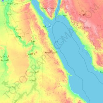
Name: Red Sea topographic map, elevation, terrain.

Location: Red Sea, Egypt (21.99367 31.78811 29.13873 37.11535)

Average elevation: 336 m

Minimum elevation: -21 m

Maximum elevation: 2,519 m

Other topographic maps

Click on a map to view its topography, its elevation and its terrain.

Marsa Matruh

Egypt > Matruh

Average elevation: 37 m

Al Kharja Oases

Egypt > New Valley

Average elevation: 95 m

Giza

Egypt > Giza

Average elevation: 72 m

Fustat

Egypt > Cairo > Cairo > El Sheikh Mubarak

Average elevation: 29 m

Ramadan Moustafa

Egypt > Tanta

Average elevation: 12 m

Siwa Oasis

Egypt > Matruh

Average elevation: 30 m

Katameya Heights Compound

Egypt > Cairo > Cairo

Average elevation: 244 m

New Aswan

Egypt > Aswan

Average elevation: 137 m

Sidi Abdel Rahman

Egypt > Matruh

Average elevation: 13 m

Gannet ElAref

Egypt > Matruh

Average elevation: 4 m

Arish

Egypt > North Sinai

Average elevation: 29 m

El Faroukiya

Egypt > Cairo > Cairo

Average elevation: 28 m

May Fair

Egypt > Cairo > Cairo

Average elevation: 188 m

Cold spring

Egypt > Matruh > Siwa Oasis

Average elevation: 38 m

Top view desert stp

Egypt > Matruh > Siwa Oasis

Average elevation: -13 m

Aswan

Egypt > Aswan

Average elevation: 184 m

Alexandria

Egypt > Alexandria

Average elevation: 0 m

Abu Simbel City

Egypt > Aswan

Average elevation: 184 m

Dahab

Egypt > Shibh Jazirat Sina'

Average elevation: 261 m

Shatby

Egypt > Alexandria > Alexandria

Average elevation: 8 m

Damanhur

Egypt > The Lake

Average elevation: 2 m

Shubra al Khayma

Egypt > Al Qalyubiya

Average elevation: 45 m

Tizmant East Village

Egypt > Bani Sweif

Average elevation: 30 m

Madaba

Egypt > Asyut

Average elevation: 83 m

Hurghada

Egypt > Red Sea

Average elevation: 32 m

Mudiriyat al Gharbiyah

Egypt > Seberbay

Average elevation: 46 m

Birimbal al Quadima

Egypt > Damietta

Average elevation: 2 m

Asyut

Egypt > Asyut

Köppen-Geiger climate classification system classifies its climate as hot desert (BWh). It is the driest city of Egypt. Luxor, Minya, Qena and Asyut have the widest difference of temperatures between days and nights of any city in Egypt, with almost 16 °C (29 °F) difference. The city of Asyut is sandwiched…

Average elevation: 57 m

Beba

Egypt > Bani Sweif

Average elevation: 34 m

Abou Kebir City

Egypt > Eastern

Average elevation: 7 m

Rosetta

Egypt > The Lake

Average elevation: 2 m

Jazīrat ‘Awwāḑ

Egypt > Aswan > Shash

Average elevation: 201 m

Badr

Egypt > Cairo

Average elevation: 212 m

El Qattameya City

Egypt > Cairo > Cairo

Average elevation: 232 m

New Damietta

Egypt > Damietta

Average elevation: 1 m

El Sheikh Mubarak

Egypt > Cairo > Cairo

Average elevation: 27 m

El Alamein

Egypt > Matruh

Average elevation: 19 m

Ismailia Governorate

Egypt

Average elevation: 188 m

International Park

Egypt > Cairo > Cairo

Average elevation: 119 m

West of Suhail

Egypt > Aswan

Average elevation: 132 m

North Sinai Governorate

Egypt

Average elevation: 353 m

South Sinai Governorate

Egypt

Average elevation: 406 m

Al Riyadh

Egypt

Average elevation: 4 m

Ain Sokhna

Egypt > Suez

Average elevation: 38 m

Matrouh Governorate

Egypt

Average elevation: 101 m

Damietta

Egypt > Damietta

Average elevation: 0 m

Luxor City

Egypt > Luxor

Average elevation: 78 m

Bani Sweif

Egypt > Bani Sweif

Average elevation: 61 m

6th of October

Egypt > Giza

Average elevation: 141 m

Sheikh Zayed

Egypt > Giza > Sheikh Zayed

Average elevation: 103 m

New Al Qarnh City

Egypt > Luxor > New Al Qarnh City

Average elevation: 123 m

Saqaltah City

Egypt > Suhaj > Saqaltah City

Average elevation: 68 m

Saqiyat Makki

Egypt > Giza Governorate > Saqiyat Makki

Average elevation: 23 m

abutisht

Egypt > Qena Governorate > abutisht

Average elevation: 67 m

New Assiut

Egypt > Asyut Governorate > New Assiut

Average elevation: 148 m

Ashmoun

Egypt > Al Minufiya

Average elevation: 14 m

Samanoud City

Egypt > Samanoud City

Average elevation: 7 m

New Administrative Capital

Egypt > Cairo

Average elevation: 301 m

Cairo

Egypt > Cairo

Average elevation: 66 m

New Cairo City

Egypt > Cairo

New Cairo is built in the Eastern Desert to the east of the Cairo Ring Road and the modern 1950s extension of Nasr City, on a plateau that ranges in elevation between 250 and 307 metres (820 and 1,007 ft) above sea level.

Average elevation: 227 m

Al Ismailiya

Egypt > Al Ismailiya

Average elevation: 21 m

Qaryat Shakush

Egypt > Alexandria > Qaryat Shakush

Average elevation: 8 m

Sharm el-Sheikh

Egypt > South Sinai > Sharm el-Sheikh

Average elevation: 135 m

Al Arish

Egypt > North Sinai > Al Arish

Average elevation: 33 m