
Thank you for supporting this site ❤️
Make a donation
Make a donation
Madaba topographic map
Click on the map to display elevation.
Thank you for supporting this site ❤️
Make a donation
Make a donation
About this map
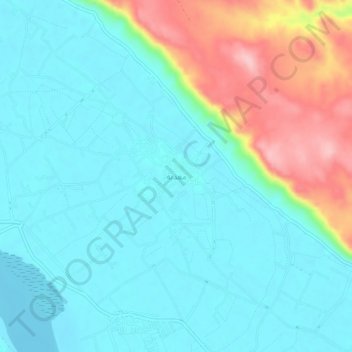
Name: Madaba topographic map, elevation, terrain.
Location: Madaba, Asyut, Egypt (27.31751 31.00368 27.35751 31.04368)
Average elevation: 83 m
Minimum elevation: 42 m
Maximum elevation: 206 m
Thank you for supporting this site ❤️
Make a donation
Make a donation
Other topographic maps
Click on a map to view its topography, its elevation and its terrain.
Asyut
Köppen-Geiger climate classification system classifies its climate as hot desert (BWh). It is the driest city of Egypt. Luxor, Minya, Qena and Asyut have the widest difference of temperatures between days and nights of any city in Egypt, with almost 16 °C (29 °F) difference. The city of Asyut is sandwiched…
Average elevation: 57 m