
Thank you for supporting this site ❤️
Make a donation
Make a donation
Cairo topographic map
Click on the map to display elevation.
Thank you for supporting this site ❤️
Make a donation
Make a donation
About this map
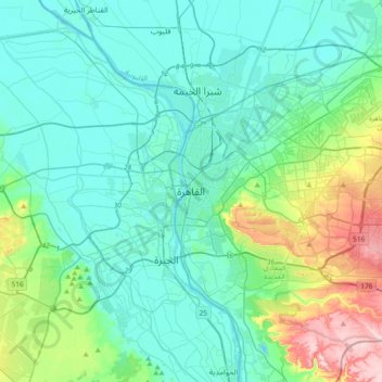
Name: Cairo topographic map, elevation, terrain.
Location: Cairo, 11519, Egypt (29.88439 31.07573 30.20439 31.39573)
Average elevation: 66 m
Minimum elevation: 5 m
Maximum elevation: 330 m
Thank you for supporting this site ❤️
Make a donation
Make a donation
Other topographic maps
Click on a map to view its topography, its elevation and its terrain.
New Cairo City
New Cairo is built in the Eastern Desert to the east of the Cairo Ring Road and the modern 1950s extension of Nasr City, on a plateau that ranges in elevation between 250 and 307 metres (820 and 1,007 ft) above sea level.
Average elevation: 227 m