
Thank you for supporting this site ❤️
Make a donation
Make a donation
New Cairo City topographic map
Click on the map to display elevation.
Thank you for supporting this site ❤️
Make a donation
Make a donation
New Cairo City
New Cairo is built in the Eastern Desert to the east of the Cairo Ring Road and the modern 1950s extension of Nasr City, on a plateau that ranges in elevation between 250 and 307 metres (820 and 1,007 ft) above sea level.
Thank you for supporting this site ❤️
Make a donation
Make a donation
About this map
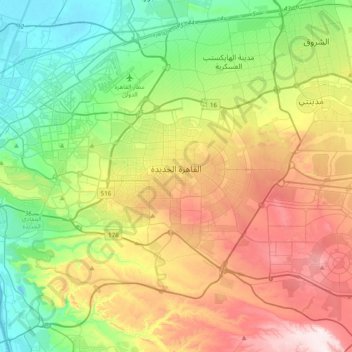
Name: New Cairo City topographic map, elevation, terrain.
Location: New Cairo City, Cairo, Egypt (29.92303 31.36036 30.11761 31.74657)
Average elevation: 227 m
Minimum elevation: 11 m
Maximum elevation: 580 m
Thank you for supporting this site ❤️
Make a donation
Make a donation
Other topographic maps
Click on a map to view its topography, its elevation and its terrain.