
Addis Ababa topographic map
Interactive map
Click on the map to display elevation.
About this map
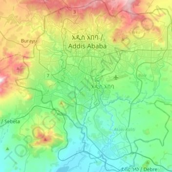
Name: Addis Ababa topographic map, elevation, terrain.
Location: Addis Ababa, Ethiopia (8.83311 38.63990 9.09858 38.90805)
Average elevation: 2,371 m
Minimum elevation: 2,044 m
Maximum elevation: 3,195 m
Moreover, the city held strong social organization patterns prior to the Italian invasion. According to Richard Pankhurst (1968), the city's accelerated population growth was due to factors of provisional governors and their troops, the 1892 famine, and eventually the Battle of Adwa. Another includes the 1907 land act, municipal administration in 1909, and a railway and modernized transportation system boom beginning in the 20th century, culminating in continual growth. Additional supplements, for example the laying of Ethio-Djibouti Railways and topographical factors further led the city's boundary to expand southward.
Other topographic maps
Click on a map to view its topography, its elevation and its terrain.
Sanghi
Sanghi, North Gondar, Amhara Region, Ethiopia
Average elevation: 1,181 m
Addis Ababa
Ethiopia > Addis Ababa > Arada
Addis Ababa, Arada, Addis Ababa, 3578, Ethiopia
Average elevation: 2,517 m
Blue Nile
Blue Nile, South Gonder, Amhara Region, Ethiopia
Average elevation: 1,649 m
Ambo
Ethiopia > Oromia Region > Ambo Zuria
Ambo, Ambo Zuria, West Shewa, Oromia Region, Ethiopia
Average elevation: 2,384 m
Jinka
Ethiopia > Southern Nations, Nationalities, and Peoples
Jinka, South Omo, Southern Nations, Nationalities, and Peoples, Ethiopia
Average elevation: 1,478 m
Bahir Dar Special Zone
Bahir Dar Special Zone, Amhara Region, Ethiopia
Average elevation: 1,794 m
Butajira
Ethiopia > Southern Nations, Nationalities, and Peoples
Butajira, Guraghe, Southern Nations, Nationalities, and Peoples, Ethiopia
Average elevation: 2,078 m
Arba Minch
Ethiopia > Southern Nations, Nationalities, and Peoples
Arba Minch, Gamo Gofa, Southern Nations, Nationalities, and Peoples, Ethiopia
Average elevation: 1,455 m
Kella Soiama
Kella Soiama, Kelem Wellega, Oromia Region, Ethiopia
Average elevation: 1,677 m
Chenna
Ethiopia > Southern Nations > Chenna
Chenna, Kaffa, Southern Nations, Ethiopia
Average elevation: 1,327 m
Hora Califo
Hora Califo, Jijiga, Somali Region, Ethiopia
Average elevation: 1,309 m
Khumera
Ethiopia > Tigray Region > Humera
Khumera, Humera, Western Tigray, Tigray Region, Ethiopia
Average elevation: 586 m
Ahmar Mountains
Ahmar Mountains, West Harerghe, Oromia Region, Ethiopia
Average elevation: 1,777 m
Simien Mountains National Park
Simien Mountains National Park, Gich, North Gonder, Amhara, Ethiopia
Average elevation: 2,337 m
Nekemte
Ethiopia > Oromia Region > Nekemte
Nekemte, East Wellega, Oromia Region, Ethiopia
Average elevation: 1,910 m