
Bati topographic map
Interactive map
Click on the map to display elevation.
About this map
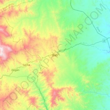
Name: Bati topographic map, elevation, terrain.
Location: Bati, Oromia, Amhara Region, Ethiopia (11.03163 39.85975 11.35163 40.17975)
Average elevation: 1,450 m
Minimum elevation: 953 m
Maximum elevation: 2,525 m
Bati (Oromo: Baati; Amharic: ባቲ) is a town in north-central Ethiopia. Located in the Oromia Zone of the Amhara Region, east of Dessie this town has a latitude and longitude of 11°11′N 40°1′E / 11.183°N 40.017°E / 11.183; 40.017 with an elevation of 1502 metres above sea level. It is the largest town in Bati woreda.
Other topographic maps
Click on a map to view its topography, its elevation and its terrain.
Blue Nile
Blue Nile, South Gonder, Amhara Region, Ethiopia
Average elevation: 1,649 m
Bahir Dar Special Zone
Bahir Dar Special Zone, Amhara Region, Ethiopia
Average elevation: 1,794 m