
Adama topographic map
Interactive map
Click on the map to display elevation.
About this map
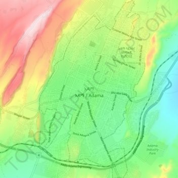
Name: Adama topographic map, elevation, terrain.
Location: Adama, Oromia Region, 0408, Ethiopia (8.49725 39.24379 8.59053 39.30012)
Average elevation: 1,675 m
Minimum elevation: 1,489 m
Maximum elevation: 1,978 m
Other topographic maps
Click on a map to view its topography, its elevation and its terrain.
Robe
Arsi Robe is a town in south-eastern Oromia. It is named after the nearby Robe River. It is the administrative centre of the Robe (Aanaa) in the Arsi Zone of the Oromia State, this town has a latitude and longitude of 09°36′N 39°08′E / 9.600°N 39.133°E / 9.600; 39.133 with an elevation of 2435…
Average elevation: 2,440 m
Metu
Metu (Oromo: Mattuu) is a market town and separate woreda in south-western Ethiopia. Located in the Illubabor Zone of the Oromia along the Sor River, this town has a latitude and longitude of 8°18′N 35°35′E / 8.300°N 35.583°E / 8.300; 35.583 and an altitude of 1605 meters. Metu was the capital…
Average elevation: 1,682 m
Chiro
Chiro (also called Asebe Teferi or Asba Littoria; Afaan Oromo: Ciroo) is a town and Aanaa in eastern Ethiopia. Located in the West Hararghe Zone in Oromia Regional State, Ethiopia Ahmar Mountains, it has a latitude and longitude of 9°05′N 40°52′E / 9.083°N 40.867°E / 9.083; 40.867 and an…
Average elevation: 1,870 m
Entoto
Ethiopia > Oromia Region > Sululta
The Ethiopian Heritage Trust, a non-profit, non-governmental organization, is working actively to change part of the mountain to its old state, a natural park. Entoto Natural Park is the northeastern rim of Addis Abeba, on the southeastern slopes of Mt. Entoto, covering an area of 1,300 hectares. It is…
Average elevation: 3,019 m
Harena Forest
The Harenna Forest is a montane tropical evergreen forest in Ethiopia's Bale Mountains. The forest covers the southern slope of the mountains, extending from 1450 to 3200 meters elevation. The Bale Mountains are in Ethiopia's Oromia Region, and form the southwestern portion of the Ethiopian Highlands.
Average elevation: 2,028 m
Sire
Sire (also transliterated "Sirie") is a town in south-western Oromia. Located in the Arsi Zone of the Oromia, Ethiopia. This town has a latitude and longitude of 08°17′N 39°27′E / 8.283°N 39.450°E / 8.283; 39.450 with an altitude of 1793 meters above sea level. It is administrative center of…
Average elevation: 2,033 m
Asassa
Asasa is a town in southeastern Ethiopia. Located in the West Arsi Zone of the Oromia Region, this town has a latitude and longitude of 07°06′N 39°12′E / 7.100°N 39.200°E / 7.100; 39.200 with an elevation of 2367 meters above sea level. It is the administrative center of Gedeb Asasa woreda.
Average elevation: 2,382 m
Moyale
Moyale has a hot semi-arid climate (Köppen BSh) moderated somewhat by altitude. Typically for East Africa, there are two rainy seasons: the “long rains” from March to May and the weaker, less reliable “short rains” in October and November.
Average elevation: 1,095 m
Agaro
Agaro (also spelled Haggaro) (Oromo: Aggaaroo) is a town and separate woreda in south-western Ethiopia. Located in the Jimma Zone of the Oromia Region, it sits at an elevation of 1,560 meters above sea level.
Average elevation: 1,677 m
Sokoru
The altitude of this woreda ranges from 1160 to 2940 meters above sea level; the highest points include Ali Shashema, Ali Derar and Kumbi. Perennial rivers include the Gilgel Gibe a tributary of the Gibe, and the Kawar; seasonal streams include the Melka Luku. A survey of the land in this woreda shows that…
Average elevation: 1,827 m
Waliso
Waliso (Oromo: Walisoo) is a town in Southwest Shewa Zone of the Oromia Region in Ethiopia, 114 km southwest of Addis Ababa, it has a latitude and longitude of 8°32′N 37°58′E / 8.533°N 37.967°E / 8.533; 37.967 with an elevation of 2063 meters above sea level. Waliso is the administrative center of this Zone.
Average elevation: 2,044 m
Adama
Ethiopia > Oromia Region > Adama
Adama (Oromo: Adaamaa or Hadaamaa, Amharic: አዳማ), formerly Nazreth (Amharic: ናዝሬት), is a city in central Oromia Region, Ethiopia. Adama forms a Special Zone of Oromia and is surrounded by East Shewa Zone. It is located at 8°32′N 39°16′E / 8.54°N 39.27°E / 8.54; 39.27 at an…
Average elevation: 1,673 m
Waliso
Waliso (Oromo: Walisoo) is a town in Southwest Shewa Zone of the Oromia Region in Ethiopia, 114 km southwest of Addis Ababa, it has a latitude and longitude of 8°32′N 37°58′E / 8.533°N 37.967°E / 8.533; 37.967 with an elevation of 2063 meters above sea level. Waliso is the administrative center of this Zone.
Average elevation: 2,044 m
Asela
Asella (Oromo: Asallaa, Amharic: አሰላ) is a town in central Ethiopia. Located in the Arsi Zone of the Oromia Region 126 km (78 mi) south from Addis Ababa, this town has a latitude and longitude of 7°57′N 39°7′E / 7.950°N 39.117°E / 7.950; 39.117, with an elevation of 2,430 meters. Asella…
Average elevation: 2,429 m
Naqamte
Nekemte, also spelled as Neqemte (Oromo: Naqamtee, Amharic: ነቀምት), is a market city and separate woreda in western Ethiopia. Located in the East Welega Zone of the Oromia Region, Nekemte has a latitude and longitude of 9°5′N 36°33′E / 9.083°N 36.550°E / 9.083; 36.550 and an elevation of 2,088 meters.
Average elevation: 1,909 m
Ambo
Ethiopia > Oromia Region > Ambo Zuria
Ambo (Oromo: Amboo) is a town in west-central Ethiopia. Located in the West Shewa Zone of Oromia Region, west of Addis Ababa. And it is the capital city of West Shewa zone. This town has a latitude and longitude of 8°59′N 37°51′E / 8.983°N 37.850°E / 8.983; 37.850 and an elevation of 2,101 meters.
Average elevation: 2,384 m
Negele
Negele Borana or Neghelle, is a town and separate woreda in southern Ethiopia. Located in the Guji Zone of the Oromia Region on the road connecting Addis Ababa to Dolo Odo, it is the largest town in the Guji Zone, traditionally inhabited by the Borana Oromo. Specifically the town's inhabitants are mostly…
Average elevation: 1,494 m
Entoto
Ethiopia > Oromia Region > Sululta
The Ethiopian Heritage Trust, a non-profit, non-governmental organization, is working actively to change part of the mountain to its old state, a natural park. Entoto Natural Park is the northeastern rim of Addis Abeba, on the southeastern slopes of Mt. Entoto, covering an area of 1,300 hectares. It is…
Average elevation: 3,019 m