
Oromia Region topographic map
Interactive map
Click on the map to display elevation.
About this map
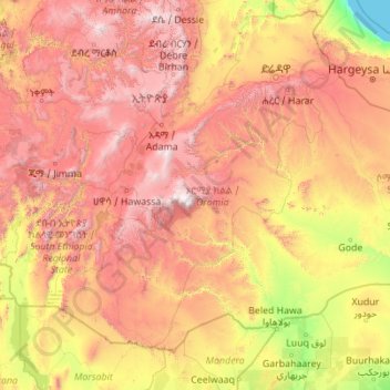
Name: Oromia Region topographic map, elevation, terrain.
Location: Oromia Region, Ethiopia (3.50945 34.14552 10.39131 42.98080)
Average elevation: 1,173 m
Minimum elevation: 0 m
Maximum elevation: 4,277 m
Other topographic maps
Click on a map to view its topography, its elevation and its terrain.
Naqamte
Nekemte, also spelled as Neqemte (Oromo: Naqamtee, Amharic: ነቀምት), is a market city and separate woreda in western Ethiopia. Located in the East Welega Zone of the Oromia Region, Nekemte has a latitude and longitude of 9°5′N 36°33′E / 9.083°N 36.550°E / 9.083; 36.550 and an elevation of 2,088 meters.
Average elevation: 1,909 m
Jinka
Ethiopia > Southern Nations, Nationalities, and Peoples
Jinka is a market town in southern Ethiopia. Located in the hills north of the Tama Plains, this town is the capital of the Debub Omo Zone of the Southern Nations, Nationalities, and Peoples Region. Currently Jinka is the center of Jinka town administration. Jinka has a latitude and longitude of 5°47′N…
Average elevation: 1,478 m
Ambo
Ethiopia > Oromia Region > Ambo Zuria
Ambo (Oromo: Amboo) is a town in west-central Ethiopia. Located in the West Shewa Zone of Oromia Region, west of Addis Ababa. And it is the capital city of West Shewa zone. This town has a latitude and longitude of 8°59′N 37°51′E / 8.983°N 37.850°E / 8.983; 37.850 and an elevation of 2,101 meters.
Average elevation: 2,384 m
Addis Ababa
Ethiopia > Addis Ababa > Arada
Moreover, the city held strong social organization patterns prior to the Italian invasion. According to Richard Pankhurst (1968), the city's accelerated population growth was due to factors of provisional governors and their troops, the 1892 famine, and eventually the Battle of Adwa. Another includes the 1907…
Average elevation: 2,517 m
Bati
Bati (Oromo: Baati; Amharic: ባቲ) is a town in north-central Ethiopia. Located in the Oromia Zone of the Amhara Region, east of Dessie this town has a latitude and longitude of 11°11′N 40°1′E / 11.183°N 40.017°E / 11.183; 40.017 with an elevation of 1502 metres above sea level. It is the…
Average elevation: 1,450 m
Adwa
Adwa (Tigrinya: ዓድዋ; Amharic: ዐድዋ; also spelled Aduwa) is a town and separate woreda in Tigray Region, Ethiopia. It is best known as the community closest to the site of the 1896 Battle of Adwa, in which Ethiopian soldiers defeated Italian troops, thus being one of the few African nations to thwart…
Average elevation: 1,962 m
Adigrat
Adigrat (Tigrinya: ዓዲግራት, ʿaddigrat, also called ʿAddi Grat) is a city and separate woreda in the Tigray Regional State of Ethiopia. It is located in the Misraqawi Zone at longitude and latitude 14°16′N 39°27′E / 14.267°N 39.450°E / 14.267; 39.450Coordinates: 14°16′N…
Average elevation: 2,557 m