
Adama topographic map
Interactive map
Click on the map to display elevation.
About this map
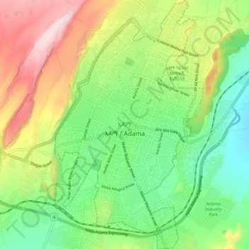
Name: Adama topographic map, elevation, terrain.
Location: Adama, Oromia Region, 0408, Ethiopia (8.49725 39.24379 8.59053 39.30012)
Average elevation: 1,676 m
Minimum elevation: 1,489 m
Maximum elevation: 1,978 m
Other topographic maps
Click on a map to view its topography, its elevation and its terrain.
Naqamte
Nekemte, also spelled as Neqemte (Oromo: Naqamtee, Amharic: ነቀምት), is a market city and separate woreda in western Ethiopia. Located in the East Welega Zone of the Oromia Region, Nekemte has a latitude and longitude of 9°5′N 36°33′E / 9.083°N 36.550°E / 9.083; 36.550 and an elevation of 2,088 meters.
Average elevation: 1,909 m
Ambo
Ethiopia > Oromia Region > Ambo Zuria
Ambo (Oromo: Amboo) is a town in west-central Ethiopia. Located in the West Shewa Zone of Oromia Region, west of Addis Ababa. And it is the capital city of West Shewa zone. This town has a latitude and longitude of 8°59′N 37°51′E / 8.983°N 37.850°E / 8.983; 37.850 and an elevation of 2,101 meters.
Average elevation: 2,384 m