
Adwa topographic map
Interactive map
Click on the map to display elevation.
About this map
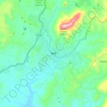
Name: Adwa topographic map, elevation, terrain.
Location: Adwa, Central Tigray, Tigray, Ethiopia (14.12707 38.85116 14.20707 38.93116)
Average elevation: 1,962 m
Minimum elevation: 1,821 m
Maximum elevation: 2,460 m
Adwa (Tigrinya: ዓድዋ; Amharic: ዐድዋ; also spelled Aduwa) is a town and separate woreda in Tigray Region, Ethiopia. It is best known as the community closest to the site of the 1896 Battle of Adwa, in which Ethiopian soldiers defeated Italian troops, thus being one of the few African nations to thwart European colonialism. Located in the Central Zone of the Tigray Region, Adwa has a longitude and latitude of 14°10′N 38°54′E / 14.167°N 38.900°E / 14.167; 38.900Coordinates: 14°10′N 38°54′E / 14.167°N 38.900°E / 14.167; 38.900, and an elevation of 1907 meters. Adwa is surrounded by Adwa woreda.
Other topographic maps
Click on a map to view its topography, its elevation and its terrain.