
Make a donation
Amhara Region topographic map
Click on the map to display elevation.
Make a donation
Amhara Region
The Amhara region has the most world heritage sites of any region in Ethiopia and is endowed with natural and geographic wonders and ecosystems. The region contains Ethiopia's largest inland body of water Lake Tana, which is the source of the Blue Nile river. In 2015 Lake Tana was recognized as a UNESCO Biosphere Reserve for its enormous biodiversity, and national and international importance. The Semien Mountains National Park has been designated as the one of the first natural World Heritage Site by UNESCO in the world, and the very first in Africa in the natural criteria since 1978. Chosen for its spectacular landscapes and global significance for biodiversity conservation. Situated within the Semien Mountains, Ethiopia's highest peaks Ras Dashen reaches an elevation of (4,543 m (14,905 ft)). The park also has Ethiopia's second and third highest mountains, Kidis Yared (4,453 m (14,610 ft)) and Mount Bwahit (4,437 m (14,557 ft)). The park is home to endangered species found nowhere else in the world, examples of endemic fauna include the iconic walia ibex, the gelada baboon, and the Ethiopian wolf (or Simien fox) among others. The wide range of altitudes has given the country a variety of ecologically distinct areas, leading to the evolution of endemic species in ecological isolation.
Make a donation
About this map
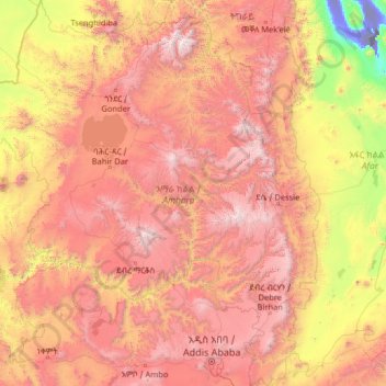
Name: Amhara Region topographic map, elevation, terrain.
Location: Amhara Region, Ethiopia (8.71589 35.26165 13.78090 40.21334)
Average elevation: 1,618 m
Minimum elevation: -114 m
Maximum elevation: 4,454 m
Make a donation
Other topographic maps
Click on a map to view its topography, its elevation and its terrain.
Naqamte
Nekemte, also spelled as Neqemte (Oromo: Naqamtee, Amharic: ነቀምት), is a market city and separate woreda in western Ethiopia. Located in the East Welega Zone of the Oromia Region, Nekemte has a latitude and longitude of 9°5′N 36°33′E / 9.083°N 36.550°E / 9.083; 36.550 and an elevation of 2,088 meters.
Average elevation: 1,909 m
Make a donation
Make a donation
Ambo
Ethiopia > Oromia Region > Ambo Zuria
Ambo (Oromo: Amboo) is a town in west-central Ethiopia. Located in the West Shewa Zone of Oromia Region, west of Addis Ababa. And it is the capital city of West Shewa zone. This town has a latitude and longitude of 8°59′N 37°51′E / 8.983°N 37.850°E / 8.983; 37.850 and an elevation of 2,101 meters.
Average elevation: 2,384 m
Addis Ababa
Ethiopia > Addis Ababa > Arada
Moreover, the city held strong social organization patterns prior to the Italian invasion. According to Richard Pankhurst (1968), the city's accelerated population growth was due to factors of provisional governors and their troops, the 1892 famine, and eventually the Battle of Adwa. Another includes the 1907…
Average elevation: 2,517 m
Make a donation
Adwa
Adwa (Tigrinya: ዓድዋ; Amharic: ዐድዋ; also spelled Aduwa) is a town and separate woreda in Tigray Region, Ethiopia. It is best known as the community closest to the site of the 1896 Battle of Adwa, in which Ethiopian soldiers defeated Italian troops, thus being one of the few African nations to thwart…
Average elevation: 1,962 m
Bati
Bati (Oromo: Baati; Amharic: ባቲ) is a town in north-central Ethiopia. Located in the Oromia Zone of the Amhara Region, east of Dessie this town has a latitude and longitude of 11°11′N 40°1′E / 11.183°N 40.017°E / 11.183; 40.017 with an elevation of 1502 metres above sea level. It is the…
Average elevation: 1,450 m
Make a donation
Adigrat
Adigrat (Tigrinya: ዓዲግራት, ʿaddigrat, also called ʿAddi Grat) is a city and separate woreda in the Tigray Regional State of Ethiopia. It is located in the Misraqawi Zone at longitude and latitude 14°16′N 39°27′E / 14.267°N 39.450°E / 14.267; 39.450Coordinates: 14°16′N…
Average elevation: 2,557 m
Make a donation