
駒ヶ岳 topographic map
Interactive map
Click on the map to display elevation.
About this map
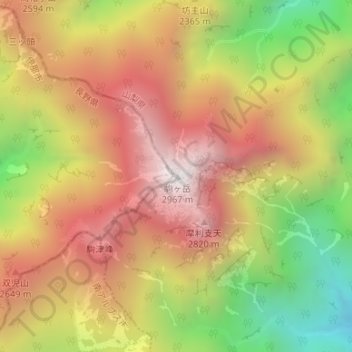
Name: 駒ヶ岳 topographic map, elevation, terrain.
Location: 駒ヶ岳, 伊那市, 長野県, 日本 (35.75792 138.23667 35.75802 138.23677)
Average elevation: 2,317 m
Minimum elevation: 1,544 m
Maximum elevation: 2,939 m
甲斐駒ヶ岳(かいこまがたけ)は、南アルプス国立公園内の赤石山脈(南アルプス)北端の山梨県北杜市と長野県伊那市にまたがる標高2,967 mの山である。峻険な山容をもち、半ば独立峰のような姿勢で屹立する日本アルプス屈指の名峰で、日本百名山、新日本百名山、新・花の百名山、山梨百名山、信州百名山、日本百景に選定されている。
Other topographic maps
Click on a map to view its topography, its elevation and its terrain.