
Okinawa Island topographic map
Interactive map
Click on the map to display elevation.
About this map
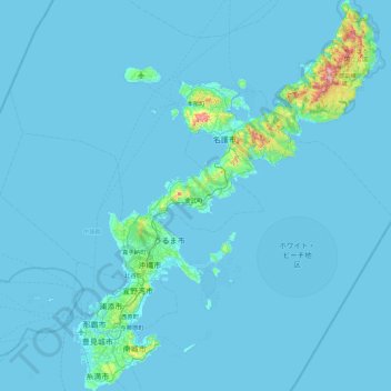
Name: Okinawa Island topographic map, elevation, terrain.
Location: Okinawa Island, Okinawa Prefecture, Japan (26.07446 127.62856 26.87552 128.32764)
Average elevation: 14 m
Minimum elevation: 0 m
Maximum elevation: 483 m
The Motobu Peninsula in the north has limestone layers and karst development. In the center and south is mainly a Ryukyu limestone layer and mudstone. The topography is flat, there are few hills over 100 m (328 ft) with very few rivers. The subtropical rains accelerates erosion so there are many drainages and uvala. The southern end of the island consists of uplifted coral reef, whereas the northern half has proportionally more igneous rock. The easily eroded limestone of the south has many caves, the most famous of which is Gyokusendō in Nanjō. The northernmost Cape Hedo is only 22 km (14 mi) away from Yoronjima. Cape Arasaki is the southernmost location of Okinawa island. It is sometimes confused with Cape Kiyanmisaki.
Other topographic maps
Click on a map to view its topography, its elevation and its terrain.
Motoyama
Motoyama, Nagaoka County, Kochi Prefecture, 781-3601, Japan
Average elevation: 679 m
Niki
Niki, Yoichi County, Shiribeshi Subprefecture, Hokkaido Prefecture, Japan
Average elevation: 269 m
Kusatsu
Kusatsu, Agatsuma County, Gunma Prefecture, Japan
Average elevation: 1,171 m
Kansai Region
Japan > Chubu Region > Nagoya
Kansai Region, Joto, Osaka Prefecture, Japan
Average elevation: 194 m
Nidan Fall
Nidan Fall, Matsumoto, Nagano Prefecture, Japan
Average elevation: 2,048 m
Jodogahama Observation Spot
Jodogahama Observation Spot, 浄土ヶ浜自然歩道, 鍬ヶ崎, Miyako, Iwate Prefecture, 027-0076, Japan
Average elevation: 22 m
Tsuwano
Tsuwano, Kanoashi County, Shimane Prefecture, Japan
Average elevation: 330 m