
Make a donation
Montana topographic map
Click on the map to display elevation.
Make a donation
Montana
Montana's topography is marked by dramatic contrasts, offering a rich tapestry of landscapes. The state is divided into three main regions: the vast, rolling plains in the east, the rugged Rocky Mountains in the west, and the transition zone between these two. The eastern plains are part of the Great Plains, characterized by expansive grasslands, gently rolling hills, and wide river valleys, with minimal precipitation and semi-arid conditions. These plains are interrupted by isolated mountain ranges such as the Bear Paw and Little Rocky Mountains. The western part of the state is dominated by the Rocky Mountains, featuring steep, forested slopes, narrow valleys, and high peaks, including Granite Peak, which rises to 12,807 feet ((3,904 meters). Here, snow-covered mountains, active glaciers, and clear, cold lakes are common, particularly in areas like Glacier National Park. Between these extremes, the Central Front forms a transitional landscape with prairies, badlands, and smaller mountain ranges, bridging the plains and the mountains.
Make a donation
About this map
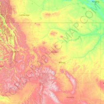
Name: Montana topographic map, elevation, terrain.
Location: Montana, United States (44.35792 -116.04923 49.00111 -104.03956)
Average elevation: 1,357 m
Minimum elevation: 552 m
Maximum elevation: 4,034 m
Make a donation
Other topographic maps
Click on a map to view its topography, its elevation and its terrain.
Kula
United States > Hawaii > Maui County
Kula is a district and census-designated place (CDP) of Maui, Hawaii, that stretches across the "up-country", the western-facing slopes of Haleakalā, from Makawao to Kanaio. Most of the residential areas lie between about 500 to 1,100 m (1,600 to 3,600 ft) in elevation. The district has traditionally been…
Average elevation: 740 m
Tallahassee
United States > Florida > Leon County > Tallahassee
Tallahassee's terrain is hilly by Florida standards, being at the southern end of the Red Hills Region, just above the Cody Scarp. The elevation varies from near sea level to just over 200 feet (61 m), with the state capitol on one of the highest hills in the city. The city includes two large lake basins, Lake…
Average elevation: 32 m
Make a donation
Jupiter Inlet Light
United States > Florida > Palm Beach County > Jupiter
The Jupiter Inlet Light is located in Jupiter, Florida, on the north side of the Jupiter Inlet. The site for the lighthouse was chosen in 1853. It is located between Cape Canaveral Light and Hillsboro Inlet Light. The lighthouse was designed by then Lieutenant George G. Meade of the Bureau of Topographical…
Average elevation: 4 m
Ellisdale
United States > New Jersey > Monmouth County > Upper Freehold Township
Average elevation: 34 m
Make a donation
Make a donation
Lituya Glacier
United States > Alaska > Unorganized Borough
It is partially responsible for creating the 1958 Lituya Bay megatsunami. The glacier, which has receded over the years, carved Lituya Bay into a unique topographic phenomenon with steep walls, a very deep submerged bottom, and a very narrow entrance to the ocean which created the opportunity for a megatsunami…
Average elevation: 952 m
Make a donation
South Gulf Cove Park
United States > Florida > Charlotte County > Port Charlotte
Average elevation: 3 m
Make a donation
Make a donation
Make a donation
Make a donation
Make a donation
Lakeland Highlands
United States > Florida > Polk County > Bartow > Lakeland Highlands
Average elevation: 64 m
Make a donation
Deep Creek
United States > Virginia > Accomack County
It lies at an elevation of 3 feet.
Average elevation: 1 m
Make a donation
Lake Ella
United States > Florida > Leon County > Tallahassee
In 1986, Lake Ella underwent extensive rehabilitation including sediment removal, reshaping of the shoreline, reducing the number of stormwater inflow pipes, and installation of an automatic alum treatment system. Lake Ella receives stormwater runoff from an urban watershed that is approximately 157 acres…
Average elevation: 56 m
Make a donation
Hillsborough River Estates
United States > Florida > Hillsborough County > Tampa
Average elevation: 14 m
Mount Rushmore
United States > South Dakota > Pennington County
The Mount Rushmore National Memorial is a national memorial centered on a colossal sculpture carved into the granite face of Mount Rushmore (Lakota: Tȟuŋkášila Šákpe, or Six Grandfathers) in the Black Hills near Keystone, South Dakota, United States. Sculptor Gutzon Borglum designed the sculpture, called…
Average elevation: 1,562 m
Make a donation
Make a donation
Brawley
United States > California > Imperial County
Brawley is located in the Colorado Desert and Lower Colorado River Valley regions. The city's elevation, like other Imperial Valley towns, is below sea level.
Average elevation: -44 m
Make a donation
Make a donation
Lake Sal Dam
United States > Georgia > Bulloch County > Statesboro > Pate Place
Average elevation: 64 m
Make a donation
Make a donation
Make a donation
Rancocas Woods
United States > New Jersey > Burlington County > Mount Laurel Township
Average elevation: 12 m
San Juan South Estates Colonia
United States > Texas > Hidalgo County > San Juan
Average elevation: 34 m
Rocky Butte
United States > Oregon > Multnomah County > Portland
Rocky Butte lies in the northeast part of Portland within the city limits, in Multnomah County, part of the U. S. state of Oregon. It is one of the few smaller volcanic cones within or near Portland, along with Mount Tabor, Kelly Butte, and Powell Butte. According to the U.S. National Geodetic Survey, Rocky…
Average elevation: 67 m
Make a donation
Shady Groove Park And Baseball Field
United States > Mississippi > George County > Central
Average elevation: 60 m
Make a donation
Make a donation
Make a donation
McCormick's Creek State Park
United States > Indiana > Owen County
The heart of the park is McCormick's Creek Canyon. The upper levels of the canyon are around 700 feet (210 m) above sea levels, dropping to the west fork of the White River which is near 540 feet (160 m). The McCormick's Creek waterfall is a primary attraction of the park, as Indiana has few waterfalls due to…
Average elevation: 205 m
Culmerville
United States > Pennsylvania > Allegheny County > West Deer Township
Average elevation: 341 m
Make a donation
Make a donation