
Make a donation
Gilroy Hot Springs topographic map
Click on the map to display elevation.
Make a donation
About this map
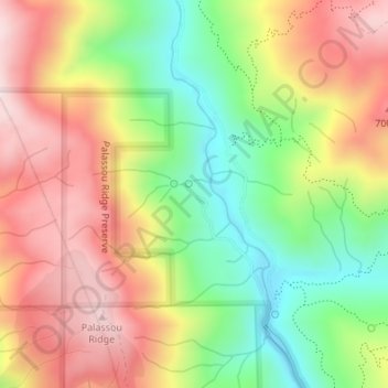
Name: Gilroy Hot Springs topographic map, elevation, terrain.
Average elevation: 525 m
Minimum elevation: 278 m
Maximum elevation: 772 m
Make a donation
Other topographic maps
Click on a map to view its topography, its elevation and its terrain.
Sierra Vista Open Space Preserve
United States > California > Santa Clara County > San Jose
Average elevation: 484 m
Morgan Hill
United States > California > Santa Clara County
Morgan Hill is approximately 24 mi (39 km) south of downtown San Jose, 13 mi (21 km) north of Gilroy, and 15 mi (24 km) inland from the Pacific coast. Lying in a roughly 4-mile-wide (6 km) southern extension of the Santa Clara Valley, it is bounded by the Santa Cruz Mountains to the west and the Diablo Range…
Average elevation: 153 m
Make a donation
Santa Clara
United States > California > Santa Clara County
In 1905, the first public high-altitude flights by humans were made over Santa Clara in gliders designed by John J. Montgomery. The semiconductor industry, which sprouted around 1960, changed the city and surrounding Valley of Heart's Delight; little of its agricultural past remains.
Average elevation: 18 m
Palo Alto
United States > California > Santa Clara County
The official elevation is 30 feet (9 m) above sea level, but the city boundaries reach well into the northern section of the Santa Cruz Mountains.
Average elevation: 186 m