
Thank you for supporting this site ❤️
Make a donation
Make a donation
Czar topographic map
Click on the map to display elevation.
Thank you for supporting this site ❤️
Make a donation
Make a donation
About this map
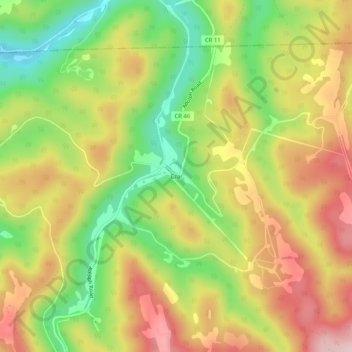
Name: Czar topographic map, elevation, terrain.
Location: Czar, Randolph County, West Virginia, 26224, United States (38.71011 -80.20702 38.75011 -80.16702)
Average elevation: 760 m
Minimum elevation: 605 m
Maximum elevation: 913 m
Thank you for supporting this site ❤️
Make a donation
Make a donation
Other topographic maps
Click on a map to view its topography, its elevation and its terrain.
Elkins
United States > West Virginia > Randolph County
Elkins is located at the confluence of the Tygart Valley River and Leading Creek. The average elevation is 2,000 feet (610 m) above sea level. According to the United States Census Bureau, the city has a total area of 3.43 square miles (8.88 km2), all land. Elkins is headquarters for the Monongahela National…
Average elevation: 637 m