
Thank you for supporting this site ❤️
Make a donation
Make a donation
Saddlebrooke topographic map
Click on the map to display elevation.
Thank you for supporting this site ❤️
Make a donation
Make a donation
About this map
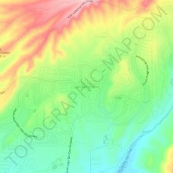
Name: Saddlebrooke topographic map, elevation, terrain.
Location: Saddlebrooke, Pinal County, Arizona, United States (32.51475 -110.90057 32.55475 -110.86057)
Average elevation: 1,029 m
Minimum elevation: 949 m
Maximum elevation: 1,139 m
Thank you for supporting this site ❤️
Make a donation
Make a donation