
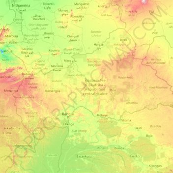
Central African Republic topographic map
Interactive map
Click on the map to display elevation.
About this map
Name: Central African Republic topographic map, elevation, terrain.
Location: Central African Republic (2.22561 14.41485 11.00139 27.46655)
Average elevation: 514 m
Minimum elevation: 192 m
Maximum elevation: 2,770 m
Much of the country consists of flat or rolling plateau savanna approximately 500 metres (1,640 ft) above sea level. In addition to the Fertit Hills in the northeast of the Central African Republic, there are scattered hills in the southwest regions. In the northwest is the Yade Massif, a granite plateau with an altitude of 348 metres (1,143 ft). The Central African Republic contains six terrestrial ecoregions: Northeastern Congolian lowland forests, Northwestern Congolian lowland forests, Western Congolian swamp forests, East Sudanian savanna, Northern Congolian forest-savanna mosaic, and Sahelian Acacia savanna.
Other topographic maps
Click on a map to view its topography, its elevation and its terrain.
Montreal
Canada > Quebec > Urban agglomeration of Montreal > Montreal
Montreal, Urban agglomeration of Montreal, Montreal (06), Quebec, H3B 1M7, Canada
Average elevation: 30 m
Sri Lanka
Sri Lanka
Average elevation: 50 m
Tacoma
United States > Washington > Pierce County
Tacoma, Pierce County, Washington, United States
Average elevation: 67 m
Bengaluru
India > Karnataka > Bangalore North
Bengaluru, Bangalore North, Bengaluru Urban District, Karnataka, India
Average elevation: 881 m
Hyderabad
India > Telangana > Bahadurpura mandal
Hyderabad, Bahadurpura mandal, Hyderabad District, Telangana, India
Average elevation: 549 m
Madurai
India > Tamil Nadu > Madurai
Madurai, Madurai South, Madurai district, Tamil Nadu, India
Average elevation: 138 m
India
India
Average elevation: 1,017 m
Kurunegala
Sri Lanka > North Western Province
Kurunegala, Kurunegala District, North Western Province, 60000, Sri Lanka
Average elevation: 146 m
Snohomish County
Snohomish County, Washington, United States
Average elevation: 649 m
Kasimov
Kasimov, Ryazan Oblast, Central Federal District, Russia
Average elevation: 124 m
Chennai
India > Tamil Nadu > Chennai
Chennai, Chennai District, Tamil Nadu, India
Average elevation: 8 m
Labinsk
Russia > Krasnodar Krai > Labinsky District
Labinsk, Лабинское городское поселение, Labinsky District, Krasnodar Krai, Southern Federal District, Russia
Average elevation: 282 m
Hagala State
Hagala State, Kandy District, Central Province, Sri Lanka
Average elevation: 1,050 m
Panwila
Panwila, Kandy District, Central Province, 20810, Sri Lanka
Average elevation: 755 m
Malvern
United Kingdom > England > Worcestershire > Malvern Hills
Malvern, Malvern Hills, Worcestershire, England, WR14 2HX, United Kingdom
Average elevation: 95 m
Oryol
Oryol, Oryol Oblast, Central Federal District, Russia
Average elevation: 196 m
Kursk
Kursk, Kursk Oblast, Central Federal District, 305000, Russia
Average elevation: 192 m
Подлитовье
Russia > Novgorod Oblast > Krestetsky District
Подлитовье, Krestetsky District, Novgorod Oblast, Northwestern Federal District, Russia
Average elevation: 57 m
Ocheretyne
Ocheretyne, Ocheretyne settlement hromada, Pokrovskii Raion, Donetsk Oblast, 86020, Ukraine
Average elevation: 227 m
Lonavala
India > Maharashtra > Mawal
Lonavala, Mawal, Pune, Maharashtra, 410400, India
Average elevation: 613 m
Udaipur
India > Rajasthan > Girwa Tehsil
Udaipur, Girwa Tehsil, Udaipur District, Rajasthan, 313001, India
Average elevation: 656 m
Siliguri
India > West Bengal > Siliguri Subdivsion
Siliguri, Siliguri Subdivsion, Darjeeling District, West Bengal, India
Average elevation: 121 m
Thanjavur
India > Tamil Nadu > Thanjavur
Thanjavur, Thanjavur District, Tamil Nadu, 613001, India
Average elevation: 49 m
Pittsburgh
United States > Pennsylvania > Allegheny County
Pittsburgh, Allegheny County, Pennsylvania, United States
Average elevation: 303 m
Timashevsk
Russia > Krasnodar Krai > Timashyovsky District
Timashevsk, Тимашёвское городское поселение, Timashyovsky District, Krasnodar Krai, Southern Federal District, 352700, Russia
Average elevation: 17 m
San Isidro
San Isidro, Cantón Atenas, Alajuela Province, 20504, Costa Rica
Average elevation: 913 m
Hays County
United States of America > Texas
Hays County, Texas, United States of America
Average elevation: 285 m
Asundi
India > Karnataka > Bellary taluk
Asundi, Bellary taluk, Ballari District, Karnataka, India
Average elevation: 419 m
Musi River
Musi River, Hyderabad, Uppal mandal, Medchal–Malkajgiri, Telangana, 5000036, India
Average elevation: 490 m
Juno
South Africa > Limpopo > Capricorn District Municipality > Aganang Local Municipality
Juno, Aganang Local Municipality, Capricorn District Municipality, Limpopo, South Africa
Average elevation: 1,104 m
Chasiv Yar
Chasiv Yar, Chasiv Yar urban hromada, Bakhmut Raion, Donetsk Oblast, 84551-84556, Ukraine
Average elevation: 213 m
Navi Mumbai
India > Maharashtra > Thane > Navi Mumbai
Navi Mumbai, Mumbai Metropolitan Region, Thane, Maharashtra, 400706, India
Average elevation: 30 m
Dehradun
India > Uttarakhand > Dehradun
Dehradun, Dehradun District, Uttarakhand, 248001, India
Average elevation: 904 m
Nepal
Nepal
Average elevation: 2,604 m
Кущёвское сельское поселение
Russia > Krasnodar Krai > Kushchovsky District
Кущёвское сельское поселение, Kushchovsky District, Krasnodar Krai, Southern Federal District, Russia
Average elevation: 48 m