
Make a donation
Samburu topographic map
Click on the map to display elevation.
Make a donation
About this map
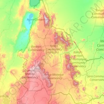
Name: Samburu topographic map, elevation, terrain.
Location: Samburu, Rift Valley, Kenya (0.56462 36.28950 2.51323 38.07929)
Average elevation: 977 m
Minimum elevation: 275 m
Maximum elevation: 2,812 m
Make a donation
Other topographic maps
Click on a map to view its topography, its elevation and its terrain.
Make a donation
Sleeping Warrior (Delamare's Nose)
Kenya > Nakuru > Gilgil > Mbaruk/Eburu ward > Ututu
Average elevation: 1,850 m
Make a donation
Make a donation
Mombasa
Kenya > Mombasa County > Mvita
Being a coastal town, Mombasa is characterised by a flat topography. The town of Mombasa is centred on Mombasa Island, but extends to the mainland. The island is separated from the mainland by two creeks, Port Reitz in the south and Tudor Creek in the north.
Average elevation: 32 m
Make a donation
Make a donation
Make a donation
Nakuru
Kenya > Nakuru > Nakuru West
On 3 June 2021, Nakuru was officially endorsed for city status after the Kenyan Senate voted for its elevation from a municipality. Following the approval of the Senate of Kenya in June, the President of the Republic of Kenya gave a city charter for official transformation of Nakuru to a city status in…
Average elevation: 1,921 m