
Thank you for supporting this site ❤️
Make a donation
Make a donation
Nakuru topographic map
Click on the map to display elevation.
Thank you for supporting this site ❤️
Make a donation
Make a donation
Nakuru
On 3 June 2021, Nakuru was officially endorsed for city status after the Kenyan Senate voted for its elevation from a municipality. Following the approval of the Senate of Kenya in June, the President of the Republic of Kenya gave a city charter for official transformation of Nakuru to a city status in December 1, 2021, making it the fourth city in Kenya after Nairobi, Mombasa and Kisumu.
Thank you for supporting this site ❤️
Make a donation
Make a donation
About this map
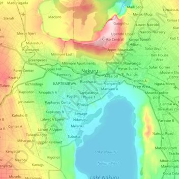
Name: Nakuru topographic map, elevation, terrain.
Location: Nakuru, Nakuru West, Nakuru, Rift Valley, 20100, Kenya (-0.35577 36.01620 -0.24231 36.19426)
Average elevation: 1,921 m
Minimum elevation: 1,754 m
Maximum elevation: 2,276 m
Thank you for supporting this site ❤️
Make a donation
Make a donation