
Belarus topographic map
Interactive map
Click on the map to display elevation.
About this map
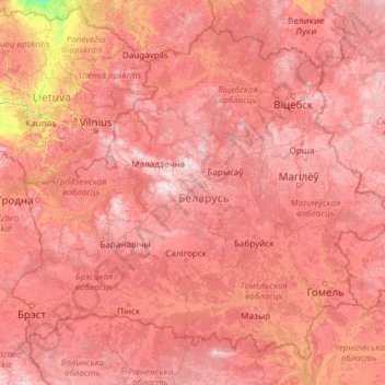
Name: Belarus topographic map, elevation, terrain.
Location: Belarus (51.26269 23.17833 56.17225 32.76278)
Average elevation: 153 m
Minimum elevation: 13 m
Maximum elevation: 328 m
The highest point is Dzyarzhynskaya Hara (Dzyarzhynsk Hill) at 345 metres (1,132 ft), and the lowest point is on the Neman River at 90 m (295 ft). The average elevation of Belarus is 160 m (525 ft) above sea level. The climate features mild to cold winters, with January minimum temperatures ranging from −4 °C (24.8 °F) in southwest (Brest) to −8 °C (17.6 °F) in northeast (Vitebsk), and cool and moist summers with an average temperature of 18 °C (64.4 °F). Belarus has an average annual rainfall of 550 to 700 mm (21.7 to 27.6 in). The country is in the transitional zone between continental climates and maritime climates.
Other topographic maps
Click on a map to view its topography, its elevation and its terrain.
India
India
Average elevation: 1,017 m
Montreal
Canada > Quebec > Urban agglomeration of Montreal > Montreal
Montreal, Urban agglomeration of Montreal, Montreal (06), Quebec, H3B 1M7, Canada
Average elevation: 30 m
Madurai
India > Tamil Nadu > Madurai
Madurai, Madurai South, Madurai district, Tamil Nadu, India
Average elevation: 138 m
Sri Lanka
Sri Lanka
Average elevation: 50 m
Ocheretyne
Ocheretyne, Ocheretyne settlement hromada, Pokrovskii Raion, Donetsk Oblast, 86020, Ukraine
Average elevation: 227 m
Kandy
Kandy, Kandy District, Central Province, 20000, Sri Lanka
Average elevation: 621 m
Hyderabad
India > Telangana > Bahadurpura mandal
Hyderabad, Bahadurpura mandal, Hyderabad District, Telangana, India
Average elevation: 549 m
Bengaluru
India > Karnataka > Bangalore North
Bengaluru, Bangalore North, Bengaluru Urban District, Karnataka, India
Average elevation: 881 m
Ooty Lake
India > Tamil Nadu > Udhagamandalam > Udhagamandalam
Ooty Lake, Udhagamandalam, The Nilgiris District, Tamil Nadu, 643001, India
Average elevation: 2,235 m
Dehradun
India > Uttarakhand > Dehradun
Dehradun, Dehradun District, Uttarakhand, 248001, India
Average elevation: 904 m
Pune
India > Maharashtra > Pune City > Pune
Pune, Pune City, Pune District, Maharashtra, 411001, India
Average elevation: 641 m
Show Low
United States > Arizona > Navajo County
Show Low, Navajo County, Arizona, 85901, United States
Average elevation: 1,957 m
Juno
South Africa > Limpopo > Capricorn District Municipality > Aganang Local Municipality
Juno, Aganang Local Municipality, Capricorn District Municipality, Limpopo, South Africa
Average elevation: 1,104 m
Devanahalli
India > Karnataka > Devanahalli taluk
Devanahalli, Devanahalli taluk, Bengaluru Rural District, Karnataka, 562110, India
Average elevation: 900 m
Tacoma
United States > Washington > Pierce County
Tacoma, Pierce County, Washington, United States
Average elevation: 67 m
Tibane
Algeria > Bejaia > Chemini District
Tibane, Chemini District, Bejaia, 06730, Algeria
Average elevation: 626 m
Chasiv Yar
Chasiv Yar, Chasiv Yar urban hromada, Bakhmut Raion, Donetsk Oblast, 84551-84556, Ukraine
Average elevation: 213 m
Panvel
India > Maharashtra > Panvel > Panvel
Panvel, Raigad, Maharashtra, 410206, India
Average elevation: 75 m
Snohomish County
Snohomish County, Washington, United States
Average elevation: 649 m
Lake Kerere
Uganda > Kabarole > Nyabweya A
Lake Kerere, Nyabweya A, Kabarole, Western Region, Uganda
Average elevation: 1,212 m
West Hollywood
West Hollywood, California, United States
Average elevation: 122 m
Haywood County
United States > North Carolina
Haywood County, North Carolina, United States
Average elevation: 1,044 m
Musi River
Musi River, Hyderabad, Uppal mandal, Medchal–Malkajgiri, Telangana, 5000036, India
Average elevation: 490 m
Hays County
United States of America > Texas
Hays County, Texas, United States of America
Average elevation: 285 m
Nepal
Nepal
Average elevation: 2,604 m
Rampura
India > Madhya Pradesh > Gyaraspur Tahsil
Rampura, Gyaraspur Tahsil, Vidisha District, Madhya Pradesh, India
Average elevation: 460 m
Kabul
Afghanistan > Kabul Province > Kabul District
Kabul, Kabul District, Kabul Province, 1001, Afghanistan
Average elevation: 1,945 m
Bodhupatti
India > Tamil Nadu > Namakkal
Bodhupatti, Namakkal, Namakkal District, Tamil Nadu, 637002, India
Average elevation: 193 m
Central Camp
United States > California > Madera County
Central Camp, Madera County, California, United States
Average elevation: 1,745 m
gehunlad
India > Uttarakhand > Chaubatta Khal
gehunlad, Chaubatta Khal, Pauri Garhwal District, Uttarakhand, India
Average elevation: 1,625 m
Tibane
Algeria > Bejaia > Chemini District > Tibane
Tibane, Chemini District, Bejaia, 06730, Algeria
Average elevation: 607 m
Newport
United Kingdom > England > Isle of Wight
Newport, Isle of Wight, England, PO30 5HD, United Kingdom
Average elevation: 45 m
Mangaluru
India > Karnataka > Mangaluru taluk
Mangaluru, Mangaluru taluk, Dakshina Kannada District, Karnataka, 575001, India
Average elevation: 25 m
Thiruvananthapuram
India > Kerala > Thiruvananthapuram
Thiruvananthapuram, Thiruvananthapuram District, Kerala, 695001, India
Average elevation: 33 m
Navi Mumbai
India > Maharashtra > Thane > Navi Mumbai
Navi Mumbai, Mumbai Metropolitan Region, Thane, Maharashtra, 400706, India
Average elevation: 30 m
Delhi
India > Delhi > Kotwali Tehsil
Delhi, Kotwali Tehsil, Central Delhi, Delhi, 110006, India
Average elevation: 216 m