
Ost topographic map
Interactive map
Click on the map to display elevation.
About this map
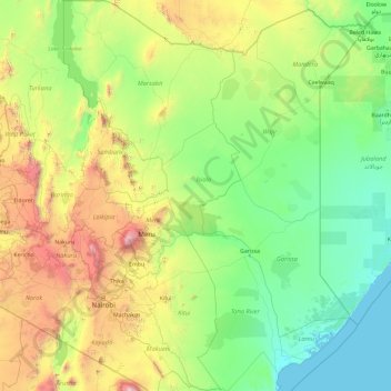
Name: Ost topographic map, elevation, terrain.
Location: Ost, Kenia (-3.07075 36.04932 4.45507 39.46290)
Average elevation: 715 m
Minimum elevation: -1 m
Maximum elevation: 5,794 m
Other topographic maps
Click on a map to view its topography, its elevation and its terrain.
Iten
Kenia > Elgeyo-Marakwet County > Keiyo North
Iten, Keiyo North, Elgeyo-Marakwet County, Rift Valley, Kenia
Average elevation: 2,284 m
Rombo
Kenia > Loitokitok > Rombo ward
Rombo, Rombo ward, Loitokitok, Rift Valley, Kenia
Average elevation: 1,170 m
Mount Kenya National Park
Mount Kenya National Park, Trail to Nelion Base, Embu, Kenia
Average elevation: 2,561 m
Athi River
Kenia > Machakos > Athi River
Athi River, Machakos, East Kenya, Kenia
Average elevation: 1,520 m
Kubi Turkana
Kenia > Isiolo > Kubi Turkana
Kubi Turkana, Isiolo, East Kenya, Kenia
Average elevation: 730 m