
Homa Bay County topographic map
Interactive map
Click on the map to display elevation.
About this map
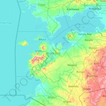
Name: Homa Bay County topographic map, elevation, terrain.
Location: Homa Bay County, Nyanza, Kenia (-0.86824 33.92540 -0.25948 35.02192)
Average elevation: 1,274 m
Minimum elevation: 1,128 m
Maximum elevation: 2,221 m
Other topographic maps
Click on a map to view its topography, its elevation and its terrain.
Iten
Kenia > Elgeyo-Marakwet County > Keiyo North
Iten, Keiyo North, Elgeyo-Marakwet County, Rift Valley, Kenia
Average elevation: 2,284 m
Rombo
Kenia > Loitokitok > Rombo ward
Rombo, Rombo ward, Loitokitok, Rift Valley, Kenia
Average elevation: 1,170 m
Mount Kenya National Park
Mount Kenya National Park, Trail to Nelion Base, Embu, Kenia
Average elevation: 2,561 m
Athi River
Kenia > Machakos > Athi River
Athi River, Machakos, East Kenya, Kenia
Average elevation: 1,520 m
Kubi Turkana
Kenia > Isiolo > Kubi Turkana
Kubi Turkana, Isiolo, East Kenya, Kenia
Average elevation: 730 m