
Arunachal Pradesh topographic map
Interactive map
Click on the map to display elevation.
About this map
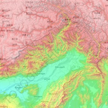
Name: Arunachal Pradesh topographic map, elevation, terrain.
Location: Arunachal Pradesh, India (26.65086 91.56231 29.38238 97.39556)
Average elevation: 2,432 m
Minimum elevation: 44 m
Maximum elevation: 7,048 m
The climate of Arunachal Pradesh varies with elevation. The low altitude (100 – 1500 m) areas have a Humid subtropical climate. High altitude and very high altitude areas (3500 – 5500 m) have a subtropical highland climate and alpine climate. Arunachal Pradesh receives 2,000 to 5,000 millimetres (79 to 197 in) of rainfall annually, 70 - 80% obtained between May and October.
Other topographic maps
Click on a map to view its topography, its elevation and its terrain.
3d
India > Rajasthan > Ganganagar Tehsil > 1 LNP
3d, 1 LNP, Ganganagar Tehsil, Sri Ganganagar District, Rajasthan, India
Average elevation: 178 m
Hyderabad
India > Telangana > Bahadurpura mandal
Hyderabad, Bahadurpura mandal, Hyderabad District, Telangana, India
Average elevation: 549 m
Thiruvananthapuram
India > Kerala > Thiruvananthapuram
Thiruvananthapuram, Thiruvananthapuram District, Kerala, 695001, India
Average elevation: 33 m
Mamidipalle
India > Telangana > Kandi mandal
Mamidipalle, Kandi mandal, Sangareddy District, Telangana, 502001, India
Average elevation: 525 m
Surat
India > Gujarat > Katargam Taluka > Surat
Surat, Katargam Taluka, Surat, Gujarat, 395001, India
Average elevation: 11 m
Jaipur
India > Rajasthan > Jaipur Tehsil
Jaipur, Jaipur Municipal Corporation, Jaipur Tehsil, Jaipur District, Rajasthan, 302001, India
Average elevation: 408 m
Letibunga
India > Uttarakhand > Dhari
Letibunga, Dhari, Nainital District, Uttarakhand, 263132, India
Average elevation: 1,970 m
Tirupati
India > Andhra Pradesh > Tirupati (Urban)
Tirupati, Tirupati (Urban), Tirupati, Andhra Pradesh, 517500, India
Average elevation: 319 m
Cheppara
India > Kerala > Talappilly > Thrissur
Cheppara, Poonamala Road, Thrissur, Talappilly, Thrissur District, Kerala, 680028, India
Average elevation: 101 m
Ooty Lake
India > Tamil Nadu > Udhagamandalam > Udhagamandalam
Ooty Lake, Udhagamandalam, The Nilgiris District, Tamil Nadu, 643001, India
Average elevation: 2,235 m
Pune
India > Maharashtra > Pune City > Pune
Pune, Pune City, Pune District, Maharashtra, 411001, India
Average elevation: 641 m
Riwai Village
India > Meghalaya > Pynursla > Nohwet Village
Riwai Village, Nohwet Village, Pynursla, East Khasi Hills District, Meghalaya, India
Average elevation: 430 m
Poomala Dam
India > Kerala > Thrissur > Thrissur
Poomala Dam, Thrissur, Thrissur District, Kerala, 680581, India
Average elevation: 99 m
Poomala
India > Kerala > Thodupuzha
Poomala, Thodupuzha, Idukki District, Kerala, 685591, India
Average elevation: 255 m
Kanyakumari district
Kanyakumari district, Tamil Nadu, India
Average elevation: 226 m
Dharamshala
India > Himachal Pradesh > Dharamshala
Dharamshala, Kangra District, Himachal Pradesh, 176200, India
Average elevation: 1,781 m
Siliguri
India > West Bengal > Siliguri Subdivsion
Siliguri, Siliguri Subdivsion, Darjeeling District, West Bengal, India
Average elevation: 121 m
Dehradun
India > Uttarakhand > Dehradun
Dehradun, Dehradun District, Uttarakhand, 248001, India
Average elevation: 904 m
Bhopal
India > Madhya Pradesh > Huzur Tahsil
Bhopal, Huzur Tahsil, Bhopal District, Madhya Pradesh, 462001, India
Average elevation: 498 m
Khag
India > Jammu and Kashmir > Beerwah tehsil
Khag, Beerwah tehsil, Budgam District, Jammu and Kashmir, 193411, India
Average elevation: 1,990 m
Khag
India > Madhya Pradesh > Rehatgarh Tahsil
Khag, Rehatgarh Tahsil, Harda District, Madhya Pradesh, India
Average elevation: 556 m
Kadamakkudy
India > Kerala > Kanayannur > Ernakulam
Kadamakkudy, Ernakulam, Kanayannur, Ernakulam District, Kerala, 682027, India
Average elevation: 0 m
Kalbog
India > Himachal Pradesh > Kotkhai
Kalbog, Kotkhai, Shimla District, Himachal Pradesh, India
Average elevation: 2,310 m
Devarayapuram
India > Andhra Pradesh > Allagadda
Devarayapuram, Allagadda, Nandyal, Andhra Pradesh, India
Average elevation: 179 m
Gudisa
India > Andhra Pradesh > Maredumilli
Gudisa, Maredumilli, Alluri Sitharama Raju, Andhra Pradesh, India
Average elevation: 974 m
Darjeeling district
Darjeeling district, West Bengal, India
Average elevation: 728 m
Anaikatti
India > Tamil Nadu > Coimbatore North
Anaikatti, Coimbatore North, Coimbatore District, Tamil Nadu, 678741, India
Average elevation: 623 m
Musi River
Musi River, Hyderabad, Uppal mandal, Medchal–Malkajgiri, Telangana, 5000036, India
Average elevation: 490 m
Billawar
Billawar, Kathua District, Jammu and Kashmir, India
Average elevation: 1,305 m
Basohli
India > Jammu and Kashmir > Bashohli
Basohli, Bashohli, Kathua District, Jammu and Kashmir, 184201, India
Average elevation: 570 m
Bani
Bani, Kathua District, Jammu and Kashmir, 184206, India
Average elevation: 2,300 m
Hiranagar
Hiranagar, Kathua District, Jammu and Kashmir, India
Average elevation: 404 m
Kreeri
Kreeri, Baramulla District, Jammu and Kashmir, India
Average elevation: 2,325 m