
Make a donation
India topographic map
Click on the map to display elevation.
Make a donation
India
India's topography is a tapestry of diverse terrains, each contributing to the country's unique geographical identity. In the north, the majestic Himalayas form a formidable barrier, with towering peaks like Kangchenjunga reaching elevations of 8,586 meters (28,169 feet), making it the highest point in India. Descending southward, the landscape transitions into the expansive Indo-Gangetic Plain, a fertile alluvial stretch nourished by rivers such as the Ganges and Brahmaputra, supporting dense agricultural activities. Central India is dominated by the Deccan Plateau, characterized by its elevated flatlands, rolling hills, and rich mineral deposits. Flanking the plateau are the Western and Eastern Ghats—continuous and discontinuous mountain ranges, respectively—that run parallel to India's coastlines, influencing monsoonal patterns and harboring rich biodiversity. The western frontier is marked by the Thar Desert's undulating sands, while the eastern and western coastal plains provide narrow, fertile stretches along the Bay of Bengal and the Arabian Sea. This intricate blend of mountains, plains, plateaus, deserts, and coastal regions underscores India's vast and varied terrain.
Make a donation
About this map
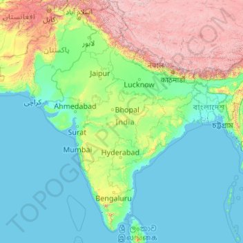
Name: India topographic map, elevation, terrain.
Location: India (6.55312 67.95444 35.67455 97.39509)
Average elevation: 1,017 m
Minimum elevation: -2 m
Maximum elevation: 7,656 m
Make a donation
Other topographic maps
Click on a map to view its topography, its elevation and its terrain.
Leh
Leh (/ˈlɛ/) (Ladakhi: གླེ) is the joint capital and largest city of Ladakh, a union territory of India. Leh, located in the Leh district, was also the historical capital of the Kingdom of Ladakh, the seat of which was in the Leh Palace, the former residence of the royal family of Ladakh, built in the…
Average elevation: 4,294 m
Make a donation
Maharashtra
Maharashtra is the third largest state by area in India. The Western Ghats better known as Sahyadri, are a hilly range running parallel to the coast, at an average elevation of 1,200 metres (4,000 ft). Kalsubai, a peak in the Sahyadris, near Nashik city is the highest elevated point in Maharashtra. To the west…
Average elevation: 478 m
Make a donation
Vadodara
India > Gujarat > Vadodara Rural Taluka
Vadodara is located at 22°18′N 73°11′E / 22.30°N 73.19°E / 22.30; 73.19 in western India at an elevation of 39 metres (128 ft). It is the tenth-largest city in India with an area of 400 square kilometres (150 sq mi) and a population of 3.5 million, according to the 2010–11 census. The city…
Average elevation: 36 m
Make a donation
Mangaluru
India > Karnataka > Mangaluru taluk
Mangalore is also the administrative headquarters of the Dakshina Kannada district; it is a commercial, industrial, educational, healthcare, and startup hub. The city's international airport is the second-largest and second-busiest airport in Karnataka. Mangalore City Corporation is responsible for the civic…
Average elevation: 25 m
Nainital
India > Uttarakhand > Nainital
The city of Nainital covers a total area of 11.73 km2 (4.53 sq mi), and is located at 29°23′N 79°27′E / 29.38°N 79.45°E / 29.38; 79.45, at an average elevation of 2,084 metres (6,837 ft) above sea level. The slopes of the nearby mountains are most populated, with an elevation ranging from…
Average elevation: 1,813 m
Make a donation
Gulmarg
India > Jammu and Kashmir > Tangmarg
Gulmarg (also known as Gulmarag, lit. 'meadow of flowers' in Kashmiri) is a hill station and a notified area committee in Baramulla district of the Indian union territory of Jammu and Kashmir. It is located in the Indian administered Kashmir, close to the Line of Control that serves as the de facto border…
Average elevation: 2,590 m
Make a donation
Karnaprayag
India > Uttarakhand > Karnaprayag
Karnaprayag is located at 30°16′N 79°15′E / 30.27°N 79.25°E / 30.27; 79.25. It has an average elevation of 860 metres (2,820 feet). The confluence of the Pindar River, which arises from the icy Pindari glacier and the Alaknanda, occurs at Karnaprayag.
Average elevation: 1,273 m
Jaynagar Majilpur
India > West Bengal > Jaynagar - I
Jaynagar Majilpur is located at 22°10′31″N 88°25′12″E / 22.1751965°N 88.4200762°E / 22.1751965; 88.4200762. It has an average elevation of 8 metres (26 ft).
Average elevation: 5 m
Pindwara
India > Rajasthan > Pindwara Tehsil
Pindwara is located at 24°47′40″N 73°03′18″E / 24.7945°N 73.055°E / 24.7945; 73.055. It has an average elevation of 372 m (1,220 ft).
Average elevation: 379 m
Make a donation
Barasat
India > West Bengal > Barasat - I
Its average elevation is 11 metres (36 ft). The nearest river is the Ganges, about 15 kilometres (9.3 mi) to the west, and it is on the Gangetic plain.
Average elevation: 6 m
Prayagraj
India > Uttar Pradesh > Prayagraj
Prayagraj's elevation is over 90 m (295 ft) above sea level. The old part of the city, at the south of Prayagraj Junction railway station, consists of neighbourhoods like Chowk, Johnstongunj, Dariyabad, Khuldabad and many more. In the north of the Railway Station, the new city consists of neighbourhoods like…
Average elevation: 91 m
Make a donation
Namakkal
India > Tamil Nadu > Namakkal
Namakkal is located at 11°14′N 78°10′E / 11.23°N 78.17°E / 11.23; 78.17. It has an average elevation of 218 metres or 715 feet. It is close to Kolli Hills – which are part of the Eastern Ghats. The closest significant river is the Kaveri and it is located 360 kilometres or 224 miles…
Average elevation: 192 m
Dehradun
India > Uttarakhand > Dehradun
The city of Dehradun mainly lies in Doon Valley and is at a varying height from 410 m (1,350 ft) in Clement Town to above 700 m (2,300 ft) at Malsi which is 15 km (9.3 mi) from the city. However, the average elevation is 450 m (1,480 ft) above sea level. Malsi is the starting point of Lesser Himalayan Range…
Average elevation: 904 m
Dandeli
India > Karnataka > Dandeli taluku
Dandeli is located at 15°16′01″N 74°37′01″E / 15.267°N 74.617°E / 15.267; 74.617. It has an average elevation of 473 metres (1,552 ft) and has received heavy rainfall during August to November (see chart below). Because of good forest cover and moderate elevation, the location has a…
Average elevation: 480 m
Make a donation
Chennai
Chennai is located on the south–eastern coast of India in the north–eastern part of Tamil Nadu on a flat coastal plain known as the Eastern Coastal Plains. Its average elevation is around 6.7 metres (22 ft), and its highest point is 60 m (200 ft). Chennai is 2,184 kilometres (1,357 mi) south of Delhi,…
Average elevation: 7 m
Make a donation
Dhupguri
India > West Bengal > Dhupguri
Dhupguri has an average elevation of 80 metres (262 feet), and is a municipality in the Jalpaiguri district. In the foothills of the Bhutanese Himalayas, the Jaldhaka River flows through the west of the town. The Daina, Gilandi, Duduya, Kumlai, Jhumur, and Bamni are other rivers which flow through the town.
Average elevation: 77 m
Make a donation
Dharamshala
India > Himachal Pradesh > Dharamshala
Dharamshala has an average elevation of 1,457 m (4,780 ft), covering an area of almost 8.51 km2 (3.29 sq mi). Dharamsala is located in the Kangra Valley, in the shadow of the Dhauladhar mountains.
Average elevation: 1,781 m
Ankara
Ankara has a cold semi-arid climate (Köppen climate classification: BSk). Under the Trewartha climate classification, Ankara has a temperate humid continental climate (Dc). Due to its elevation and inland location, Ankara has cold and snowy winters, and hot and dry summers. Rainfall occurs mostly during the…
Average elevation: 1,082 m
Make a donation
Make a donation
Make a donation
Pimpri-Chinchwad
India > Maharashtra > Haveli
Pimpri-Chinchwad also known as "PCMC", is a city in the Indian state of Maharashtra. The city is about 15 km (9.3 mi) northwest of the historic city of Pune, at an altitude of 590 m (1,940 ft) above sea level. It is the fifth largest city in Maharashtra and the nineteenth largest city in India and the…
Average elevation: 571 m
Make a donation
Make a donation
Navi Mumbai
India > Maharashtra > Thane > Navi Mumbai
Navi Mumbai (Marathi pronunciation: , also known by its former name New Bombay), is a planned city off the west coast of the Indian state of Maharashtra in Konkan division. The city is divided into two parts, North Navi Mumbai and South Navi Mumbai, for the individual development of Panvel Mega City, which…
Average elevation: 30 m
Kannur
India > Kerala > Kannur > Kannur
Kannur has an elevation of 1.02 metres or 3.3 feet along the coast of the Laccadive Sea, with a sandy coastal area. The city has an 8 kilometres (5.0 mi)-long seashore and a 3 kilometres (1.9 mi)-long beach at Payyambalam. Kannur is located north of Kozhikode, south of Kasargod and Mangalore, west of the…
Average elevation: 13 m
Make a donation
Salem
Salem is located at 11°40′N 78°08′E / 11.67°N 78.14°E / 11.67; 78.14, at an average elevation of 278 m (912 ft). The city is surrounded by hills: Nagaramalai on the north, Jarugumalai on the south, Kanjamalai on the west, Godumalai on the east and the Shevaroy Hills on the northeast.…
Average elevation: 418 m
Make a donation
Mumbai
Mumbai lies at the mouth of the Ulhas River on the western coast of India, in the coastal region known as the Konkan. It sits on Salsette Island (Sashti Island), which it partially shares with the Thane district. Mumbai is bounded by the Arabian Sea to the west. Many parts of the city lie just above sea level,…
Average elevation: 13 m
Make a donation
Khrew
India > Jammu and Kashmir > Pampore
Khrew is located at 34°01′12″N 74°59′24″E / 34.020°N 74.99°E / 34.020; 74.99. It has an average elevation of 1,607 metres (5,272 feet) and is located in the Kashmir valley. The area starts from Babapora to Seer Bagh and from Bathen to Androosa. Also, the foot region is extended to Ladhoo,…
Average elevation: 1,788 m
Make a donation
Make a donation
Kanker
India > Chhattisgarh > Kanker Tahsil
Kanker is located at 20°16′N 81°29′E / 20.27°N 81.49°E / 20.27; 81.49. It has an average elevation of 388 metres (1272 feet).
Average elevation: 405 m
Make a donation
Yamuna River
The source of Yamuna lies in the Yamunotri Glacier at an elevation of 6,387 metres (20,955 ft), on the southwestern slopes of Banderpooch peaks, which lie in the Mussoorie range of the Lower Himalayas, north of Haridwar in Uttarkashi district, Uttarakhand. Yamunotri temple, a shrine dedicated to the goddess…
Average elevation: 206 m
Make a donation
Make a donation
Pujali
India > West Bengal > Budge Budge - I > Pujali
Pujali is located at 22°28′04″N 88°08′43″E / 22.4678722°N 88.1452410°E / 22.4678722; 88.1452410. It has an average elevation of 9 metres (30 ft).
Average elevation: 5 m
Make a donation
Dakshina Kannada
The topography of the district is plain up to 30 km (18.64 mi) inside the coast and changes to undulating hilly terrain sharply towards the east in the Western Ghats. Teak, bamboo and rosewood trees are found in the hilly areas towards the east. The Geological Survey of India has identified this district as a…
Average elevation: 109 m
Make a donation