
Thank you for supporting this site ❤️
Make a donation
Make a donation
Barasat topographic map
Click on the map to display elevation.
Thank you for supporting this site ❤️
Make a donation
Make a donation
Barasat
Its average elevation is 11 metres (36 ft). The nearest river is the Ganges, about 15 kilometres (9.3 mi) to the west, and it is on the Gangetic plain.
Thank you for supporting this site ❤️
Make a donation
Make a donation
About this map
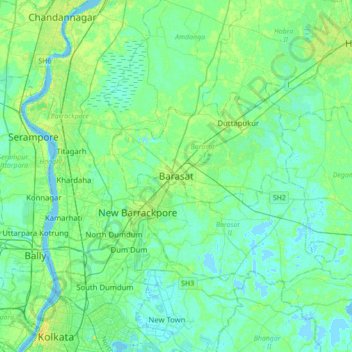
Name: Barasat topographic map, elevation, terrain.
Average elevation: 6 m
Minimum elevation: -3 m
Maximum elevation: 22 m
Thank you for supporting this site ❤️
Make a donation
Make a donation