
Betul topographic map
Click on the map to display elevation.
Betul
The mean elevation above the sea is about 2000 ft. The country is essentially a highland tract, divided naturally into three distinct portions, differing in their superficial aspects, the character of their soil and their geological formation. The northern part of the district forms an irregular plain of the sandstone formation. It is a well-wooded tract, but it has a very sparse population and little cultivated land. In the extreme north a line of hills rises abruptly out of the great plain of the Narmada valley. The central tract alone possesses a rich soil, well watered by the river Machna and Sapna dam, almost entirely cultivated and studded with villages. To the south lies a rolling plateau of basaltic formation (with the sacred town of Multai, and the springs of the Tapti River at its highest point), extending over the whole of the southern face of the district, and finally merging into the wild and broken line of the Ghats, which lead down to the plains. This tract consists of a succession of stony ridges of trap rock, enclosing valleys or basins of fertile soil, to which cultivation is for the most part confined, except where the shallow soil on the tops of the hills has been turned to account.
About this map
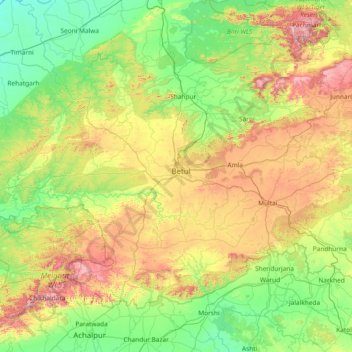
Name: Betul topographic map, elevation, terrain.
Location: Betul, Madhya Pradesh, India (21.35745 76.98616 22.40209 78.54922)
Average elevation: 533 m
Minimum elevation: 264 m
Maximum elevation: 1,294 m
Other topographic maps
Click on a map to view its topography, its elevation and its terrain.
Bhopal
India > Madhya Pradesh > Huzur Tahsil
Bhopal has an average elevation of 500 metres (1401 ft) and is located in the central part of India, just north of the upper limit of the Vindhya mountain ranges. Located on the Malwa plateau, it is higher than the north Indian plains and the land rises towards the Vindhya Range to the south. The city has…
Average elevation: 498 m
Ujjain
India > Madhya Pradesh > Ujjain NagarTahsil
Ujjain is located in the west-central part of India, and is north of the upper limit of the Vindhya mountain ranges. Located on the Malwa plateau, it is higher than the north Indian plains and the land rises towards the Vindhya Range to the south. Ujjain's co-ordinates are 23°10′N 75°46′E /…
Average elevation: 501 m
Jhabua
India > Madhya Pradesh > Jhabua Tahsil
Jhabua has an average elevation of 318 metres (1043 feet). Jhabua is located at the bottom left side of MP, mainly towards Gujarat.
Average elevation: 337 m
Sagar
India > Madhya Pradesh > Sagar Nagar Tahsil
Sagar has an average elevation of 427 metres (1401 ft) and is located in the central part of India, just north of the upper limit of the Vindhya mountain ranges.here is a lake in middle of the city.
Average elevation: 515 m
Umaria
India > Madhya Pradesh > Bandhogarh Umaria Tahsil
Umaria is located at 23°25′N 78°38′E / 23.42°N 78.63°E / 23.42; 78.63 and has an average elevation of 538 metres (1,765 feet).
Average elevation: 455 m
Damoh
India > Madhya Pradesh > Danyantinagar Tahsil
Damoh is located at 23°53′N 79°27′E / 23.88°N 79.45°E / 23.88; 79.45. It is at an average elevation of 595 metres (1,952 ft).
Average elevation: 362 m
Jabalpur
India > Madhya Pradesh > Jabalpur Tahsil > Jabalpur
The Narmada river bringing in freshwater from the Vindyachal Ranges has developed Jabalpur district into an agrarian economy. The land of the Narmada basin with its fertile alluvial soil gives good yields of sorghum, wheat, rice, and millet in the villages around Jabalpur. Important among commercial crops are…
Average elevation: 413 m
Rampur Baghelan
India > Madhya Pradesh > Rampur Baghelan Tahsil > Rampur Baghelan
Average elevation: 316 m
Jatara
India > Madhya Pradesh > Jatara Tahsil > Jatara
Jatara is located at 25°01′N 79°03′E / 25.02°N 79.05°E / 25.02; 79.05. It has an average elevation of 246 metres (807 feet).it is situated near Khajuraho and Orchha.
Average elevation: 260 m
Mahua Dol Earthen Dam Hanumanji Shiv Ganga
India > Madhya Pradesh > Pawai Tahsil > Mahuadol
Average elevation: 506 m
Dhupgarh
India > Madhya Pradesh > Pipariya Tahsil
Mount Dhupgarh or Dhoopgarh is the highest point in the Mahadeo Hills (Satpura Range), Madhya Pradesh, India. Located in Pachmarhi in Hoshangabad district, it has an elevation of 1,352 metres (4,429 ft). The top of the hill is a popular area to watch sunsets. Pachmarhi Hill station is located close to the…
Average elevation: 1,079 m
Rehti
India > Madhya Pradesh > Rehti Tahsil
Rehti is located at 22°44′N 77°26′E / 22.73°N 77.43°E / 22.73; 77.43. It has an average elevation of 303 metres (994 feet). It is located near Vindhyachal Range and surrounded by mountains. The nearest airport is Bhopal and the nearest railway station is Hoshangabad, 37 km away.
Average elevation: 306 m
Jaisinghnagar
India > Madhya Pradesh > Sagar Tahsil
Jaisinagar is located at 23°41'07.5"N 81°23'26.5"E. It has an average elevation of 593 metres (1,945 feet).
Average elevation: 567 m