
Thank you for supporting this site ❤️
Make a donation
Make a donation
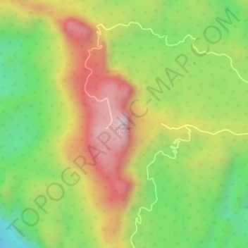
Dhupgarh topographic map
Click on the map to display elevation.
Thank you for supporting this site ❤️
Make a donation
Make a donation
Dhupgarh
Mount Dhupgarh or Dhoopgarh is the highest point in the Mahadeo Hills (Satpura Range), Madhya Pradesh, India. Located in Pachmarhi in Hoshangabad district, it has an elevation of 1,352 metres (4,429 ft). The top of the hill is a popular area to watch sunsets. Pachmarhi Hill station is located close to the peak.[
Thank you for supporting this site ❤️
Make a donation
Make a donation
About this map
Name: Dhupgarh topographic map, elevation, terrain.
Location: Dhupgarh, Pipariya Tahsil, Narmadapuram, Madhya Pradesh, India (22.44986 78.37372 22.44996 78.37382)
Average elevation: 1,079 m
Minimum elevation: 814 m
Maximum elevation: 1,334 m
Thank you for supporting this site ❤️
Make a donation
Make a donation