Geolocate

Palampur topographic map

Interactive map

Click on the map to display elevation.

About this map

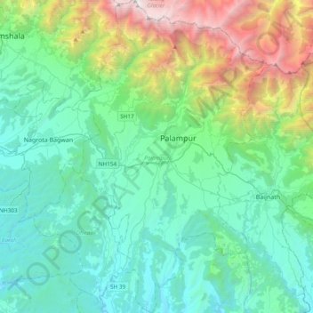
Name: Palampur topographic map, elevation, terrain.

Location: Palampur, Kangra District, Himachal Pradesh, India (31.92933 76.40704 32.25083 76.65217)

Average elevation: 1,520 m

Minimum elevation: 604 m

Maximum elevation: 4,901 m

Other topographic maps

Click on a map to view its topography, its elevation and its terrain.

Bhojnagar

India > Himachal Pradesh > Solan

Average elevation: 1,327 m

Pin Valley National Park

India > Himachal Pradesh > Spiti

Average elevation: 4,903 m

Darcha

India > Himachal Pradesh > Lahul

Darcha (elevation 3,360 m or 11,020 ft) is a pair of villages (Darcha Sumdo and Darach Dangma) on the Bhaga River in the Lahaul sub-division in the Lahaul and Spiti district in the Indian state of Himachal Pradesh. It is the northernmost permanent settlement in Himachal Pradesh along the Manali-Leh Highway.…

Average elevation: 3,702 m

Shimla

India > Himachal Pradesh > Shimla (urban)

Shimla is on the south-western ranges of the Himalayas at 31°37′N 77°06′E / 31.61°N 77.10°E / 31.61; 77.10. It has an average altitude of 2,206 metres (7,238 ft) above mean sea level and extends along a ridge with seven spurs. The city stretches nearly 9.2 kilometres (5.7 mi) from east to west.

Average elevation: 1,557 m

Nani

India > Himachal Pradesh > Theog > Matiana

Average elevation: 2,530 m

Chawai

India > Himachal Pradesh > Ani

Average elevation: 1,908 m

Kolhara

India > Himachal Pradesh > Jubbal > Jubbal

Average elevation: 2,363 m

Nagar

India > Himachal Pradesh > Kullu > Naggar

Average elevation: 1,930 m

Kasol

India > Himachal Pradesh > Bhuntar

Average elevation: 2,424 m

Fagu

India > Himachal Pradesh > Theog

Average elevation: 2,223 m

Shahul

India > Himachal Pradesh > Sainj

Average elevation: 1,648 m

Barnet

India > Himachal Pradesh > Dharamshala > Dharamshala

Average elevation: 1,426 m

Gharoh

India > Himachal Pradesh > Dharamshala

Average elevation: 1,029 m

Morang

India > Himachal Pradesh > Moorang

Average elevation: 2,755 m

Dharamshala

India > Himachal Pradesh > Dharamshala

Dharamshala has an average elevation of 1,457 m (4,780 ft), covering an area of almost 8.51 km2 (3.29 sq mi). Dharamsala is located in the Kangra Valley, in the shadow of the Dhauladhar mountains.

Average elevation: 1,781 m

Baletra

India > Himachal Pradesh > Bhattiyat > Chatoli

Average elevation: 1,478 m

Kataula

India > Himachal Pradesh > Mandi

Average elevation: 1,374 m

Dharot

India > Himachal Pradesh > Kumharsain

Average elevation: 2,126 m

Kangra

India > Himachal Pradesh

Average elevation: 1,665 m

Rihana

India > Himachal Pradesh > Karsog > Jeora

Average elevation: 944 m

Tiun

India > Himachal Pradesh > Kullu

Average elevation: 2,723 m

Kaupo

India > Himachal Pradesh > Theog > Mehana

Average elevation: 2,214 m

Basantpur

India > Himachal Pradesh > Seoni

Average elevation: 1,228 m

Rohanda

India > Himachal Pradesh > Nihri

Average elevation: 2,124 m

Dansa

India > Himachal Pradesh > Rampur

Average elevation: 2,001 m

matehr

India > Himachal Pradesh > Palampur > Palampur

Average elevation: 1,208 m

Banuri

India > Himachal Pradesh > Palampur

Average elevation: 1,254 m

matehr

India > Himachal Pradesh > Palampur > Palampur

Average elevation: 1,208 m

jalrehr

India > Himachal Pradesh > Palampur > Banuri

Average elevation: 1,259 m

Matehr

India > Himachal Pradesh > Nagrota Bagwan

Average elevation: 974 m

Shilli

India > Himachal Pradesh > Arki

Average elevation: 1,294 m

Preshi

India > Himachal Pradesh > Nihri

Average elevation: 1,668 m

Boh

India > Himachal Pradesh > Shahpur

Average elevation: 1,644 m

Chail

India > Himachal Pradesh > Kandaghat

Average elevation: 1,874 m

Chailchowk

India > Himachal Pradesh > Chachyot

Average elevation: 1,307 m

Solan

India > Himachal Pradesh > Solan

Solan is a city in the Indian state of Himachal Pradesh and the district headquarters of Solan district. It is located 45.5 kilometres (28 mi) south of the state capital, Shimla. Solan has an average elevation of 1,550 metres (5,090 ft). The city is situated between Chandigarh (joint capital of Punjab and…

Average elevation: 1,312 m

Bihar

India > Himachal Pradesh > Banjar > Banjar

Average elevation: 1,810 m

Giri

India > Himachal Pradesh > Kandaghat

Average elevation: 1,490 m

Gehra

India > Himachal Pradesh > Chamba

Average elevation: 1,847 m

Mashara

India > Himachal Pradesh > Kullu > Naggar

Average elevation: 1,696 m

Manhar

India > Himachal Pradesh > Banjar > Pekhri

Average elevation: 2,166 m

Kandhar

India > Himachal Pradesh > Seoni

Average elevation: 1,228 m

Chandratal Lake

India > Himachal Pradesh > Lahul

Average elevation: 4,403 m

Nirsu

India > Himachal Pradesh > Rampur

Average elevation: 1,238 m

Bagna

India > Himachal Pradesh > Theog

Average elevation: 2,033 m

Dunghri

India > Himachal Pradesh > Manali > Manali

Average elevation: 2,274 m

Mashara

India > Himachal Pradesh > Kullu > Naggar

Average elevation: 1,696 m

Kasauli

India > Himachal Pradesh > Kasauli

Average elevation: 1,255 m

Shikar Beh

India > Himachal Pradesh > Lahul

Average elevation: 5,476 m

Indrasan

India > Himachal Pradesh > Lahul

Mount Indrasan is located at an altitude of 6221 metres above sea level in Kullu district, Himachal Pradesh. Mt. Indrasan is considered as the most difficult mountain to climb in the Pir Panjal range of the Himalayas because of the challenges involved in scaling it. It was first climbed on October 13, 1962, by…

Average elevation: 5,374 m

Seharal

India > Himachal Pradesh > Sundarnagar > Sundarnagar

Average elevation: 1,106 m

Deotsidh

India > Himachal Pradesh > Dhatwal

Average elevation: 721 m

Bharmour

India > Himachal Pradesh > Brahmaur

Average elevation: 2,204 m

Jubbar

India > Himachal Pradesh > Theog

Average elevation: 1,915 m

Naddi

India > Himachal Pradesh > Dharamshala

Average elevation: 1,713 m

Jablog

India > Himachal Pradesh > Shimla ( Rural ) > Dianda

Average elevation: 1,680 m

Kotgarh

India > Himachal Pradesh > Kumharsain

Average elevation: 1,872 m

Kangti

India > Himachal Pradesh > Kullu > Basag

Average elevation: 1,677 m

Jharoti

India > Himachal Pradesh > Thunag > Janjheli

Average elevation: 2,270 m

Siyuri

India > Himachal Pradesh > Jogindarnagar > Joginder Nagar

Average elevation: 1,244 m

Shillai

India > Himachal Pradesh > Shalai

Average elevation: 1,556 m

Thathar

India > Himachal Pradesh > Sundarnagar > Sundarnagar

Average elevation: 954 m

Kaza

India > Himachal Pradesh > Spiti

Kaza, also spelled Kaze, Karze, Karzey, is a town and the subdivisional headquarters of the remote Spiti Valley in the western Himalayas in the Lahaul and Spiti district of the northern Indian state of Himachal Pradesh. Spiti is a high altitude or cold desert having close similarities to the neighbouring Tibet…

Average elevation: 4,161 m

बडूँ

India > Himachal Pradesh > Dera Gopipur

Average elevation: 511 m

Manali

India > Himachal Pradesh > Manali

Average elevation: 2,606 m

Rail

India > Himachal Pradesh > Theog > Bijhalta

Average elevation: 1,546 m

Po

India > Himachal Pradesh > Spiti

Average elevation: 5,212 m

Jarol

India > Himachal Pradesh > Kumharsain

Average elevation: 2,219 m

Sidhbari

India > Himachal Pradesh > Dharamshala

Average elevation: 1,197 m

Tharoch

India > Himachal Pradesh > Nerua

Average elevation: 1,840 m

Khirganga

India > Himachal Pradesh > Bhuntar

Average elevation: 3,328 m

Paundal Bunha

India > Himachal Pradesh > Padhar > Padhar

Average elevation: 1,414 m

Chakban

India > Himachal Pradesh > Dharamshala > Khaniara

Average elevation: 1,532 m

Balag

India > Himachal Pradesh > Sundarnagar

Average elevation: 976 m

Balag

India > Himachal Pradesh > Theog > Bijhalta

Average elevation: 1,503 m

Balh

India > Himachal Pradesh > Dharamshala > Dharamshala

Average elevation: 1,906 m

Kheerganga Hot Spring

India > Himachal Pradesh > Bhuntar > Khirganga

Average elevation: 3,135 m

Yunam

India > Himachal Pradesh > Lahul

Average elevation: 5,514 m

Chebar

India > Himachal Pradesh > Karsog

Average elevation: 1,353 m

Chelian

India > Himachal Pradesh > Dharamshala

Average elevation: 1,123 m

Solan

India > Himachal Pradesh > Solan

Solan is a city in the Indian state of Himachal Pradesh and the district headquarters of Solan district. It is located 45.5 kilometres (28 mi) south of the state capital, Shimla. Solan has an average elevation of 1,550 metres (5,090 ft). The city is situated between Chandigarh (joint capital of Punjab and…

Average elevation: 1,312 m

Sarchu

India > Himachal Pradesh > Lahul

Average elevation: 5,408 m

Kharota

India > Himachal Pradesh > Dharamshala > Khaniara

Average elevation: 1,713 m

Kembli

India > Himachal Pradesh > Dharamshala > Dharamshala

Average elevation: 2,113 m

Leda

India > Himachal Pradesh > Mandi

Average elevation: 1,335 m

Khirganga

India > Himachal Pradesh > Bhuntar

Average elevation: 3,328 m

Sulah

India > Himachal Pradesh > Palampur

Average elevation: 944 m

Rait

India > Himachal Pradesh > Shahpur

Average elevation: 709 m

Panchrukhi

India > Himachal Pradesh > Palampur

Average elevation: 1,045 m

Nurpur

India > Himachal Pradesh > Nurpur

Nurpur is located at 32°18′N 75°54′E / 32.3°N 75.9°E / 32.3; 75.9. It has an average elevation of 643 metres (2109 feet).

Average elevation: 536 m

Parol

India > Himachal Pradesh > Dharamshala

Average elevation: 907 m

Kotli

India > Himachal Pradesh > Kotli

Kotli Tungal (Kotli) is a small town in Himachal Pradesh, in northern India located along national highway 70 (updated 003) which connects Jalandhar (in Punjab) to Mandi. It is 22 km (14 mi) from the town of Mandi, Kotli is a Sub Division and Tehsil (Sub District) of Mandi District. Kotli and the surrounding…

Average elevation: 1,194 m

Tharot

India > Himachal Pradesh > Shahpur > Chadhi

Average elevation: 866 m

Alhilal

India > Himachal Pradesh > Baijnath

Average elevation: 1,092 m

Mahog

India > Himachal Pradesh > Theog

Average elevation: 2,006 m

Dhaula Kuan

India > Himachal Pradesh > Paonta Sahib

Average elevation: 470 m

Keylang

India > Himachal Pradesh > Lahul

Kyelang is accessible from Manali via the Manali-Leh Highway, a part of NH21. It is located about 71 km (44 mi) north of Manali at an altitude of 3,080 m (10,100 ft) and used to remain cut off from the outside world for six months from late October to mid-May due to heavy snowfall at Rohtang pass until the…

Average elevation: 3,823 m

Darcha

India > Himachal Pradesh > Lahul

Darcha (elevation 3,360 m or 11,020 ft) is a pair of villages (Darcha Sumdo and Darach Dangma) on the Bhaga River in the Lahaul sub-division in the Lahaul and Spiti district in the Indian state of Himachal Pradesh. It is the northernmost permanent settlement in Himachal Pradesh along the Manali-Leh Highway.…

Average elevation: 3,702 m

Jarol

India > Himachal Pradesh > Kumharsain

Average elevation: 2,219 m

Jagatsukh

India > Himachal Pradesh > Manali

Average elevation: 2,101 m