
Bali topographic map
Interactive map
Click on the map to display elevation.
About this map
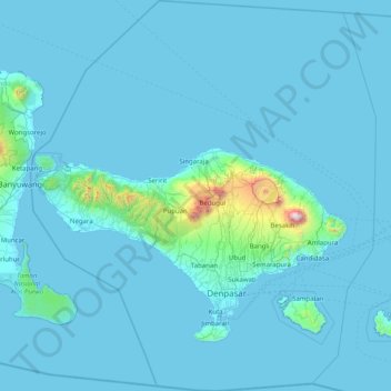
Name: Bali topographic map, elevation, terrain.
Location: Bali, Lesser Sunda Islands, Indonesia (-9.05023 114.41268 -7.46280 115.83242)
Average elevation: 88 m
Minimum elevation: -1 m
Maximum elevation: 2,917 m
Bali's central mountains include several peaks over 2,000 metres (6,600 feet) in elevation and active volcanoes such as Mount Batur. The highest is Mount Agung (3,031 m, 9,944 ft), known as the "mother mountain", which is an active volcano rated as one of the world's most likely sites for a massive eruption within the next 100 years. In late 2017 Mount Agung started erupting and large numbers of people were evacuated, temporarily closing the island's airport. Mountains range from centre to the eastern side, with Mount Agung the easternmost peak. Bali's volcanic nature has contributed to its exceptional fertility and its tall mountain ranges provide the high rainfall that supports the highly productive agriculture sector. South of the mountains is a broad, steadily descending area where most of Bali's large rice crop is grown. The northern side of the mountains slopes more steeply to the sea and is the main coffee-producing area of the island, along with rice, vegetables, and cattle. The longest river, Ayung River, flows approximately 75 km (47 mi) (see List of rivers of Bali).
Other topographic maps
Click on a map to view its topography, its elevation and its terrain.
Ruang
Indonesia > North Sulawesi > Kepulauan Siau Tagulandang Biaro > Pumpente
Ruang, Pumpente, Kepulauan Siau Tagulandang Biaro, North Sulawesi, Sulawesi, Indonesia
Average elevation: 274 m
Tutu Karue
Tutu Karue, Sigi Regency, Central Sulawesi, Sulawesi, Indonesia
Average elevation: 831 m
Pura
Indonesia > East Nusa Tenggara > Alor
Pura, Alor, East Nusa Tenggara, Lesser Sunda Islands, Indonesia
Average elevation: 275 m
City of Medan
City of Medan, North Sumatra, Sumatra, Indonesia
Average elevation: 18 m
Pedurungan
Indonesia > Central Java > Semarang
Pedurungan, Semarang, Central Java, Java, Indonesia
Average elevation: 19 m
Hutan Kota Patriot Bina Bangsa Kota Bekasi
Indonesia > West Java > Bekasi > Kayuringinjaya
Hutan Kota Patriot Bina Bangsa Kota Bekasi, Kranji, Proyek, Kayuringinjaya, Bekasi, West Java, Java, Indonesia
Average elevation: 19 m
Rengging
Rengging, Dusun Satu, Jepara, Central Java, Java, 59462, Indonesia
Average elevation: 35 m
Banjar
Banjar, South Kalimantan, Kalimantan, Indonesia
Average elevation: 95 m
Rambutan
Indonesia > Special Capital Region of Jakarta
Rambutan, Ciracas, East Jakarta, Special Capital Region of Jakarta, Java, 13830, Indonesia
Average elevation: 39 m
Lake Matano
Indonesia > South Sulawesi > Nuha
Lake Matano, Nuha, South Sulawesi, Sulawesi, Indonesia
Average elevation: 575 m
Rantepao
Indonesia > South Sulawesi > Toraja Utara
Rantepao, Toraja Utara, South Sulawesi, Sulawesi, 91831, Indonesia
Average elevation: 848 m
Sindur
Indonesia > South Sumatra > Prabumulih
Sindur, Prabumulih, South Sumatra, Sumatra, Indonesia
Average elevation: 36 m
Semanggi
Indonesia > Central Java > Blora
Semanggi, Blora, Central Java, Java, Indonesia
Average elevation: 174 m
West Nusa Tenggara
West Nusa Tenggara, Lesser Sunda Islands, Indonesia
Average elevation: 45 m
East Nusa Tenggara
East Nusa Tenggara, Lesser Sunda Islands, Indonesia
Average elevation: 31 m
Hutan Bambu Andeman Boonpring
Indonesia > East Java > Kabupaten Malang > Wonoayu
Hutan Bambu Andeman Boonpring, Jalan Raya Wonoayu, Wonoayu, Kabupaten Malang, East Java, Java, 65181, Indonesia
Average elevation: 513 m
Kuin Utara
Indonesia > South Kalimantan > Banjarmasin
Kuin Utara, North Banjarmasin, Banjarmasin, South Kalimantan, Kalimantan, 70127, Indonesia
Average elevation: 3 m
Calaca
Indonesia > North Sulawesi > Manado
Calaca, Manado, North Sulawesi, Sulawesi, 95122, Indonesia
Average elevation: 11 m
Gunung Satui
Indonesia > South Kalimantan > Banjar
Gunung Satui, Banjar, South Kalimantan, Kalimantan, Indonesia
Average elevation: 485 m
Jayawijaya
Jayawijaya, Highland Papua, Western New Guinea, Indonesia
Average elevation: 2,469 m
Tanalodu
Indonesia > East Nusa Tenggara > Ngada
Tanalodu, Ngada, East Nusa Tenggara, Lesser Sunda Islands, 86412, Indonesia
Average elevation: 1,208 m
Pondok Ranggon
Indonesia > Special Capital Region of Jakarta
Pondok Ranggon, Cipayung, East Jakarta, Special Capital Region of Jakarta, Java, 13850, Indonesia
Average elevation: 65 m
Ranomut
Indonesia > North Sulawesi > Manado
Ranomut, Manado, North Sulawesi, Sulawesi, 95129, Indonesia
Average elevation: 32 m
Cileles
Indonesia > Banten > Tangerang Regency
Cileles, Tigaraksa, Tangerang Regency, Banten, Java, 15370, Indonesia
Average elevation: 43 m
Tegal
Indonesia > Banten > Tangerang Regency > Pagedangan
Tegal, Pagedangan, Tangerang Regency, Banten, Java, 15331, Indonesia
Average elevation: 36 m
Mataram
Indonesia > West Nusa Tenggara > Kec. Selaparang
Mataram, Kec. Selaparang, West Nusa Tenggara, Lesser Sunda Islands, Indonesia
Average elevation: 22 m
Kertamulya
Indonesia > West Java > Bandung Barat
Kertamulya, Bandung Barat, West Java, Java, 40552, Indonesia
Average elevation: 706 m
Kelawi
Indonesia > Lampung > Lampung Selatan
Kelawi, Lampung Selatan, Lampung, Sumatra, Indonesia
Average elevation: 98 m
Medan
Medan, City of Medan, North Sumatra, Sumatra, Indonesia
Average elevation: 32 m
Denpasar
Indonesia > Bali > Dangin Puri
Denpasar, Dangin Puri, Denpasar Timur, Bali, Lesser Sunda Islands, 80244, Indonesia
Average elevation: 48 m