
Thank you for supporting this site ❤️
Make a donation
Make a donation
Rengging topographic map
Click on the map to display elevation.
Thank you for supporting this site ❤️
Make a donation
Make a donation
About this map
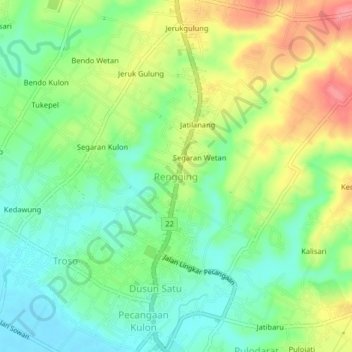
Name: Rengging topographic map, elevation, terrain.
Average elevation: 35 m
Minimum elevation: 2 m
Maximum elevation: 85 m
Thank you for supporting this site ❤️
Make a donation
Make a donation
Other topographic maps
Click on a map to view its topography, its elevation and its terrain.
Semarang
Semarang is located on the northern coast of Java. The city of Semarang is one of the most important cities located on the north coast of Java and is the main hub connecting Jakarta and Surabaya, and cities in the southern interior of Java Surakarta and Yogyakarta. Semarang City has a height ranging from 2 m…
Average elevation: 110 m
Thank you for supporting this site ❤️
Make a donation
Make a donation
Thank you for supporting this site ❤️
Make a donation
Make a donation