
Thank you for supporting this site ❤️
Make a donation
Make a donation
Medan topographic map
Click on the map to display elevation.
Thank you for supporting this site ❤️
Make a donation
Make a donation
Medan
Medan's elevation varies between 2.5 and 37.5 m (8 ft 2 in and 123 ft 0 in) above sea level, with the Barisan Mountains to the south, and volcanoes such as Sibayak Mountain and Sinabung Mountain 50 to 70 km (31 to 43 mi) from the city.
Thank you for supporting this site ❤️
Make a donation
Make a donation
About this map
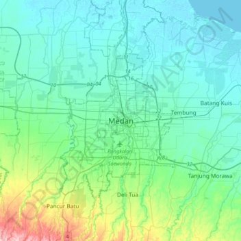
Name: Medan topographic map, elevation, terrain.
Location: Medan, City of Medan, North Sumatra, Sumatra, Indonesia (3.42967 98.51383 3.74967 98.83383)
Average elevation: 32 m
Minimum elevation: -2 m
Maximum elevation: 187 m
Thank you for supporting this site ❤️
Make a donation
Make a donation
Other topographic maps
Click on a map to view its topography, its elevation and its terrain.