
Thank you for supporting this site ❤️
Make a donation
Make a donation
Lake Matano topographic map
Click on the map to display elevation.
Thank you for supporting this site ❤️
Make a donation
Make a donation
About this map
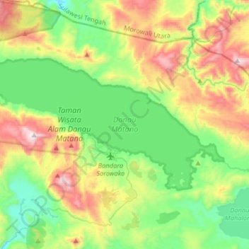
Name: Lake Matano topographic map, elevation, terrain.
Location: Lake Matano, Nuha, South Sulawesi, Sulawesi, Indonesia (-2.56554 121.21408 -2.42648 121.47512)
Average elevation: 575 m
Minimum elevation: 197 m
Maximum elevation: 1,320 m
Thank you for supporting this site ❤️
Make a donation
Make a donation