
Make a donation
Thiruverumbur topographic map
Click on the map to display elevation.
Make a donation
About this map
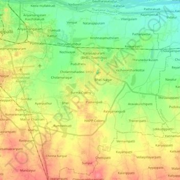
Name: Thiruverumbur topographic map, elevation, terrain.
Location: Thiruverumbur, Tiruchirappalli, Tamil Nadu, India (10.64205 78.70837 10.83921 78.88052)
Average elevation: 80 m
Minimum elevation: 53 m
Maximum elevation: 114 m
Make a donation
Other topographic maps
Click on a map to view its topography, its elevation and its terrain.
Namakkal
India > Tamil Nadu > Namakkal
Namakkal is located at 11°14′N 78°10′E / 11.23°N 78.17°E / 11.23; 78.17. It has an average elevation of 218 metres or 715 feet. It is close to Kolli Hills – which are part of the Eastern Ghats. The closest significant river is the Kaveri and it is located 360 kilometres or 224 miles…
Average elevation: 192 m
Make a donation
Chennai
Chennai is located on the south–eastern coast of India in the north–eastern part of Tamil Nadu on a flat coastal plain known as the Eastern Coastal Plains. Its average elevation is around 6.7 metres (22 ft), and its highest point is 60 m (200 ft). Chennai is 2,184 kilometres (1,357 mi) south of Delhi,…
Average elevation: 7 m
Salem
Salem is located at 11°40′N 78°08′E / 11.67°N 78.14°E / 11.67; 78.14, at an average elevation of 278 m (912 ft). The city is surrounded by hills: Nagaramalai on the north, Jarugumalai on the south, Kanjamalai on the west, Godumalai on the east and the Shevaroy Hills on the northeast.…
Average elevation: 418 m
Make a donation
Vellore
India > Tamil Nadu > Vellore
Vellore is at 12°55′N 79°08′E / 12.92°N 79.13°E / 12.92; 79.13, 220m above sea level. The city has a tropical savanna climate. It is in the Vellore district of the South Indian state, Tamil Nadu, 135 km (84 mi) west of the state capital Chennai and 30 km (19 mi) kms South of its twin city…
Average elevation: 283 m
Udhagamandalam
India > Tamil Nadu > Udhagamandalam
Ooty is situated in the Nilgiri Biosphere Reserve. Many of the forested areas and water bodies are off-limits to most visitors in order to protect this fragile ecosystem. Some areas of the Biosphere Reserve have been earmarked for tourism development, and steps are being undertaken to open these areas to…
Average elevation: 2,234 m
Make a donation
Yelagiri
India > Tamil Nadu > Tirupathur
Yelagiri (Tamil: [jeːlaɡiɾi]), also spelled Elagiri, is a hill station located in Tirupathur district of Tamil Nadu, India. Located at an altitude of 1,410 m (4,630 ft), it forms a part of the Eastern Ghats mountain range. The hills consist of 14 hamlets spread across an area of 72 km2 (28 sq mi).
Average elevation: 772 m
Make a donation
Kanchipuram
Kanchipuram is located at 12°50′19″N 79°42′06″E / 12.8387°N 79.7016°E / 12.8387; 79.7016, 72 km (45 mi) south-west of Chennai on the banks of the Vegavathi River, a tributary of the Palar River. The city covers an area of 11.6 km2 (4.5 sq mi) and has an elevation of 83.2 m (273 ft) above…
Average elevation: 82 m
Make a donation
Make a donation
Make a donation
Make a donation
Make a donation
Make a donation
Make a donation
Make a donation
Madurai
India > Tamil Nadu > Madurai
Madurai is located at 9°56′N 78°07′E / 9.93°N 78.12°E / 9.93; 78.12. It has an average elevation of 101 metres. The city of Madurai lies on the flat and fertile plain of the river Vaigai, which runs in the northwest-southeast direction through the city, dividing it into two almost equal…
Average elevation: 138 m
Make a donation
Make a donation
Make a donation
Make a donation
Alangulam
India > Tamil Nadu > Alangulam
Alangulam is located at 8°52′N 77°30′E / 8.87°N 77.5°E / 8.87; 77.5. It is situated at an average elevation of 127 metres (416 feet).
Average elevation: 120 m
Make a donation
Make a donation
Make a donation
Gangaikondan
India > Tamil Nadu > Manur
Gangaikondan is located at 8°51′N 77°47′E / 8.85°N 77.78°E / 8.85; 77.78. It has an average elevation of 47 metres (154 feet).
Average elevation: 44 m
Make a donation
Make a donation
Make a donation
Make a donation
Make a donation
Make a donation